- Campo Maior
Infobox_Municipality_pt
official_name = Campo Maior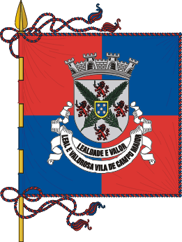
image_coat_of_arms = CMR.png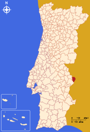
Region = Alentejo
Subregion = None
District = Portalegre
Mayor_name =João Burrica
Mayor_party = PS
area_total = 247.0
population_total = 8,359
population_density = 34
Parishes = 3
coor = 39º00'N 7º03'W
params = 39_00_N_7_03_W
occasion =Easter Monday
day = date varies
website = http://www.cm-campo-maior.pt
footnotes =Campo Maior (pron. IPA2|'kɐ̃pu mɐi'ɔɾ), population 7900, is a town and seat of the same-name municipality in the Portalegre district,
Alentejo region,Portugal .The municipality has an area of 247,26 km² and a population of 8359 (2004). It is divided into 3 parishes ("
freguesia s"). It is bordered by Spain on the North and East, by the municipality ofElvas on the Southeast, and by the municipality ofArronches on the West.Parishes
* Nossa Senhora da Expectação (Campo Maior)
* Nossa Senhora da Graça dos Degolados
* São João Baptista (Campo Maior) [Includes the old Parish of Ouguela.]Population
History
Campo Maior was certainly a Roman settling which went under control of the Moors for half a Millennium. In 1219, it was conquered by Christian knights, the Pérez de
Badajoz family, who then gave the village, which belonged to the municipality ofBadajoz , to the Church of "Santa Maria do Castelo" (Saint Mary of the Castle).On
May 31 1255 , KingAlfonso X of Castile promotes the village to town status.In 1260, Bishop Friar Pedro Pérez, the Town Lord, grants the first charter ("
fuero ") to the inhabitants of Campo Maior. He also introduced the town's firstcoat-of-arms , showingOur Lady and a lamb, with a legend "Sigillum Capituli Pacensis".On
May 31 1297 , the Treaty of Alcanizes was signed by KingFerdinand IV of Castile and KingDenis of Portugal , whereby Campo Maior, together withOlivenza and Ouguela, were transferred to Portugal.Under Portuguese
sovereignty , Campo Maior went through an additional two Town Lords - Branca, sister of King Denis, in 1301, and Afonso Sanches, natural son of King Denis, in 1312 - before returning to King Denis's direct rule in 1318.The Castle east of the village was rebuilt by King Denis in 1310. In the 17th and 18th Centuries, other
fortification s were built and Campo Maior became an importantgarrison town.As a reflex of the influence of Castile in Campo Maior, the population and the garrison sided with Castile following the
1383–1385 Crisis . KingJohn I of Portugal and ConstableNuno Álvares Pereira led their armies personally and had the town besieged for six weeks and finally occupied, in the end of 1388.King John II (1481-1495) granted a new coat-of-arms to Campo Maior: a white shield, with the Arms of Portugal on one side, and
John the Baptist ,patron saint of the town, on the other side.In 1512, King Manuel I renews the charter ("foral") of Campo Maior.
From the late 15th Century, many of those persecuted by the
Inquisition in Castile took refuge in Portugal. Part of them settled in Campo Maior, which saw its population increase substantially. As a consequence, in the 16th Century, the town'sJew ish community was so numerous that it provided most of the accused ofJudaism which were included in the Inquisition'sAuto de fe s that took place in nearbyÉvora .The war with Castile from 1640 brought big changes. The need to re-fortify the town, which had grown markedly outside the medieval perimeter during the previous three centuries, and the urgency to build a new fortified perimeter to defend the inhabitants of the "new town" from the incursions of the Castilian armies, were the reasons that forced the Kings of Portugal to invest large amounts of money, and to send contingents of military engineers, specialized workers and even more non-specialized workers. The garrison had then a substantial size. It is estimated that, in late 17th Century, one out of four inhabitants of Campo Maior was military. Campo Maior was also the main home of the mercenary Dutch troops that fought in Alentejo. The town was at that time the second most important garrison in Alentejo, after
Elvas .In 1712, the Castle of Campo Maior is besieged by the Spanish Army, commanded by the French
Alexandre Maître, Marquis de Bay . For 36 days, he launched tons of projectiles on the town and managed to breach one of thebastion s. However, upon crossing the breach, the Spanish Army suffered heavy casualties and retreated in defeat.On
September 16 1732 , at 3 am, a storm hits theArmory , located on the Castle's main tower, which contained 6000 "arrobas" of gunpowder and 5000 pieces of ammunition. A violent explosion ensued, followed by a fire, taking down two thirds of the inhabitants.King John V determines the quick reconstruction of the Castle. The town will slowly rise from the ruins and will eventually regain its main role both in times of war and in times of peace, as a trading post with Spain.
In the 18th Century, the Church of "Misericórdia" (Mercy) and the "Matriz" Church (Matrix, seat of the Parish) are built and the Church of Saint John is started. The town, which until then had been formed by a single "
freguesia " (parish), is divided in 1766 into the present two - Our Lady of "Expectação" and Saint John the Baptist.The early 1800s were agitated in Campo Maior: a siege in 1801 by the Spanish, and a local
rebellion in 1808 against the French who were then engaged in thePeninsular War .The uprising of Campo Maior against the Napoleonic invasion was successful due to the help from the
Badajoz army, which then stayed in the town for three years.In 1811, a new Napoleonic invasion besieges the town for one month until capitulation. But that gave time for a Portuguese and British contingent, under the command of British General Beresford, to arrive and disband the French. The town then earned the title of "Vila Leal e Valorosa" (Loyal and Valorous Town), now inscribed in its coat-of-arms.
The
Liberal Wars (1828-1834) were also fought in Campo Maior.In 1836, the neighbouring municipality of Ouguela was extinct and annexed to Campo Maior, increasing its number of "freguesias" (parishes) from three to four.
In 1865, an epidemy of
cholera killed 150 people in two and a half months.In 1867, an attempt to extinguish the municipality of Campo Maior and integrate it in the municipality of
Elvas provokes a popular uprising, with the population staging a strike onDecember 13 . The attempt was dropped and the municipality survived.In 1926, a fourth rural "freguesia" (parish) is added to the municipality: Our Lady of the "Graça dos Degolados" (Grace of the Beheaded).
In 1941, the municipality assumes its current division in three "freguesias" (parishes), with the annexation of the "freguesia" of Ouguela by the "freguesia" of Saint John the Baptist, due to the former's rapid population decline.
Economy
The main industry is coffee roasting and coffee packaging. Campo Maior is headquarters to
Delta Cafés , the market leader in Portugal.Other economic activities include
agriculture andlivestock rising. Campo Maior is a production center ofolive s andham , made from Iberian pig (also known as "porco alentejano").References
External links
* [http://www.cm-campo-maior.pt Municipality official website]

Wikimedia Foundation. 2010.