- Westerly State Airport
Infobox Airport
name = Westerly State Airport
nativename =
nativename-a =
nativename-r =
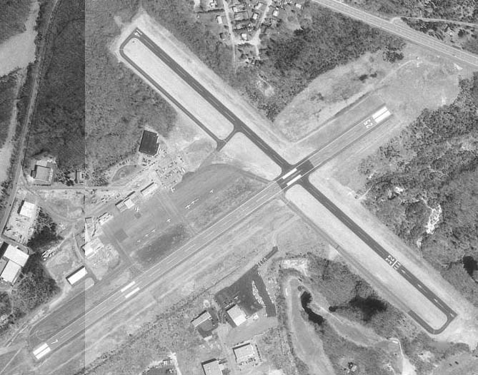
image-width =
caption =
IATA = WST
ICAO = KWST
type = Public
owner =
operator = Rhode Island Airport Corp.
city-served =
location = Westerly, Rhode Island
elevation-f = 81
elevation-m = 24.7
coordinates = Coord|41|20|58.62|N|71|48|12.16|W|type:airport|display=inline,title
website =
metric-elev =
metric-rwy =
r1-number = 7/25
r1-length-f = 4,010
r1-length-m = 1,222
r1-surface = Asphalt
r2-number = 14/32
r2-length-f = 3,960
r2-length-m = 1,207
r2-surface = Asphalt
stat-year =
stat1-header =
stat1-data =
stat2-header =
stat2-data =
footnotes =Westerly State Airport Airport codes|WST|KWST is a public
airport located two miles (3 km) southeast of Westerly, in Washington County,Rhode Island , USA. It is primarily ageneral aviation airport, but there is also scheduled airline service toBlock Island provided byNew England Airlines .Westerly State Airport is one of six active airports operated by the
Rhode Island Airport Corporation . The other five airports include T.F. Green State Airport, Newport State Airport,North Central State Airport ,Quonset State Airport , andBlock Island State Airport .Westerly State began as a grass strip in the 1920s, and became the second state-owned airport in the United States (after T.F. Green Airport) in the 1940s. The airport was paved and expanded when it became a
U.S. Navy base duringWorld War II , due to its prime location halfway between Boston andNew York City .Approximately 14,840 operations (takeoffs and landings) are conducted at the airport annually (2004 estimate).
In 2005, $3.4 million in federal funding was allocated to repair and improve the main
runway andtaxiway s. As of November 2006, improvements were finished and the main runway is open.Airline
*
New England Airlines (Block Island, Rhode Island)External links
Wikimedia Foundation. 2010.