- Stave River
Geobox River
name = Stave River
native_name =
other_name =
other_name1 =
image_size =
image_caption =
country = Canada
country1 =
state = British Columbia
state1 =
region =
region1 =
district =
district1 =
city = Mission, British Columbia
city1 =
length =
watershed =
discharge_location =
discharge_average =
discharge_max =
discharge_min =
discharge1_location =
discharge1_average =
source_name =
source_location =
source_district =
source_region =
source_state =
source_country =
source_lat_d =
source_lat_m =
source_lat_s =
source_lat_NS =
source_long_d =
source_long_m =
source_long_s =
source_long_EW =
source_elevation =
source_length =
mouth_name =
mouth_location =
mouth_district =
mouth_region =
mouth_state =
mouth_country =
mouth_lat_d =
mouth_lat_m =
mouth_lat_s =
mouth_lat_NS =
mouth_long_d =
mouth_long_m =
mouth_long_s =
mouth_long_EW =
mouth_elevation =
tributary_left =
tributary_left1 =
tributary_right =
tributary_right1 =
free_name =
free_value =
map_size = 300
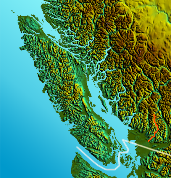
map_caption = Location map of Stave River The Stave River is a tributary of the Fraser, joining it about 35 km east ofVancouver, British Columbia ,Canada , in the CentralFraser Valley at the boundary between the municipalities of Maple Ridge and Mission.Blocked since the 1920s by two dams built by the BC Electric Railway at Stave Falls and Ruskin, the only free-flowing parts of the Stave today are the 3 km between
Ruskin Dam and the Fraser and the 45km from its source inGaribaldi Provincial Park to the head ofStave Lake . Prior to power development the total length of the river was c. 85 km.History
The name Stave River was conferred c. 1828 by
Hudson's Bay Company employees at Fort Langley, as the forests lining its banks were preferred for the production of staves used in the making of barrels for the export of fish. [cite book |last= Mackie |first= Richard Somerset |title= Trading Beyond the Mountains: The British Fur Trade on the Pacific 1793-1843 |year= 1997 |publisher= University of British Columbia (UBC) Press |location= Vancouver |isbn= 0-7748-0613-3 |pages= p. 226 online at [http://books.google.com/books?id=VKXgJw6K088C Google Books] ] The native name for the river is forgotten, although modern-day andKwantlen refer to it as "Skayuks" ("everyone died"), also the name given to one of three villages that were located in the delta marshlands of the lower reaches of the river at the time of non-native settlement (1870s onwards). The name is a reference to consequences of the successivesmallpox plagues and other disease pandemics which destroyed the populations and cultures of theFraser Valley .Terrain
The lower Stave valley comprises over half the surface territory of the District of Mission although it remains mostly forested mountainside. The terrain of the lower valley is gentle though hilly, with dense oldgrowth and dense deciduous second growth in some areas. Marginal farms, mostly pastures carved out of the forests, can be found in the Silverhill, Silverdale and Stave Gardens areas. The Stave delta, formerly an
oxbow lake , has been partly drained and dyked to form Silvermere Lake, part of a 1950s vintage real estate development; the oxbow's central island was transformed by the dredgings into a hill upon which the developer's private estate was built. It is now aRoyal Canadian Mounted Police training facility.The waters of the lower Stave are semi-tidal, as the
tidal bore on theFraser River ends farther upstream at Mission City. During the spring freshet of the Fraser the volume and force of that river's flow blocks the Stave, causing it to back up and forming a lake between the Fraser and Ruskin Dam.North of Stave Lake the Stave's valley is intensely mountainous, containing some of the most rugged terrain in the province and also some of its highest rainfalls; access is extremely difficult. Overlooking
Stave Lake at its north end are Mount Judge Howay 2262 m (7421 ft) and Mount Robie Reid 2095 m (6873 ft), and nearby are Robertson Peak 2252 m (7388 ft) and many other summits. The upper Stave basin forms the southeastern part ofGaribaldi Provincial Park , and adjoining it on its southeast is theJudge Howay Provincial Recreation Area - designated for recreation but highly inaccessibly other than to seasoned mountaineers.Fishery
The original salmon fishery was severely affected by the damming of the river but its lower stretches remain popular with sport fishermen, especially in search of steelhead. The hydro corporation has worked in cooperation with the federal
Department of Fisheries to rework the gravel bars and channels belowRuskin Dam, but this has had only marginal effect relative to the former size of the salmon runs. Stave and Hayward Lakes have a kokanee population as well as other fish such as trout, and are sometimes stocked.Industry
In addition to the
Stave Falls andRuskin dams and power plants, and a third smaller one on the shore ofStave Lake where a diversion fromAlouette Lake comes through a low mountainside, the Stave River's valley has been extensively logged. The only operating mills on its length are now near the Fraser atRuskin but there are a few ruins of mills lining its western shore, including the remains of a very large cedar shake mill adjacent to theStave Falls dam. Almost all of the mills on the Stave were focussed on the production of shakes (sort of a large shingle) and some of its mills were among the highest-producing in the world.References
External links
* [http://bcer.trams.bc.ca/pics/stavelq.jpgMap of Stave Falls Branch, BC Electric Railway]
* [http://www.bc-alter.net/dfriesen/minehunt.html The gold mines of the Stave]
Wikimedia Foundation. 2010.