- Cartago, Costa Rica
Infobox Settlement
official_name = Cartago
native_name = Cartago
nickname = "La Ciudad de las Brumas"
motto = "Fide et pace" (For the faith and the peace)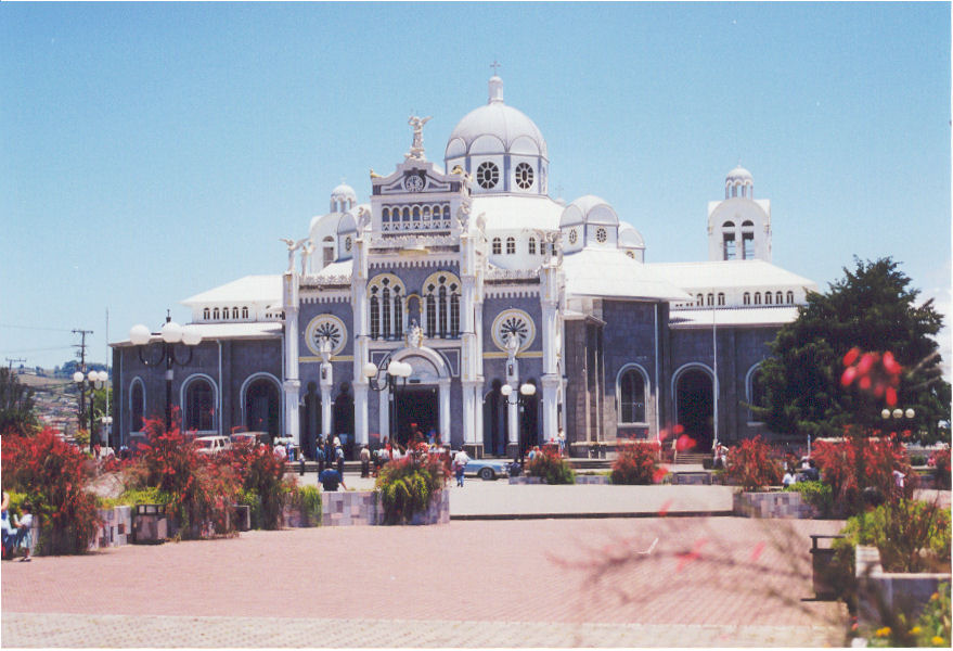
imagesize = 300px
image_caption = The Basilica de Nuestra Señora de los Angeles
image_
image_shield =
mapsize =
map_caption =
pushpin_
pushpin_mapsize =300
subdivision_type = Country
subdivision_name = flag|Costa Rica
subdivision_type1 = Province
subdivision_name1 =Cartago Province
subdivision_type2 = Canton
subdivision_name2 =Cartago Canton
government_type =
leader_title =Mayor
leader_name = Lic. Rolando Rodríguez Brenes(PLN)
leader_title1 =
leader_name1 =
leader_title2 =
leader_name2 =
leader_title3 =
leader_name3 =
established_title = Founded
established_date = 1563
established_title2 = Capital City until
established_date2 = 1823
established_title3 =
established_date3 =
area_magnitude =
unit_pref = Metric
area_footnotes =
area_total_km2 = 152.68
area_total_sq_mi =
area_land_km2 =
area_land_sq_mi =
area_water_km2 =
area_water_sq_mi =
area_water_percent =
area_urban_km2 =
area_urban_sq_mi =
area_metro_km2 =
area_metro_sq_mi =
population_as_of = 2008
population_note =
population_footnotes =
population_total = 156,600(2)
population_density_km2 =
population_density_sq_mi =
population_metro = 413,505 (2)
population_density_metro_km2 =
population_density_metro_sq_mi =
population_urban =
timezone = Central Standard Time
utc_offset = -6
timezone_DST =
utc_offset_DST =
latd = 9 | latm=52 | lats= | latNS=N
longd = 83 | longm=55 | longs= | longEW=W
elevation_m = 1435
elevation_ft = 4707
postal_code_type =
postal_code =
website = http://www.muni-carta.go.cr [http://www.prugam.go.cr/descargables/clausulas_estudio_enero_2008/economico/1-la_gam.pdf] [http://www.nu.or.cr/pnudcr/dmdocuments/ADH_07_anexo.pdf]
footnotes =HDI (2005) 0.813 – highCartago is a
city inCosta Rica , about 25 km (15 miles) east of the capital, San José. It is at an elevation of about 1435 m (some 4930 ft) abovesea level , at the base of theIrazú Volcano . Cartago is the capital ofCartago province . The city covers an area of 152,68 km². It includes the districts of city downtown: Oriental, Occidental (known as the typical downtown area), San Nicolás (the main entrance to the city, at west), El Carmen (north), San Rafael de Oreamuno (at east, is the capital of canton of Oreamuno), Dulce Nombre and San Francisco (at south, San Francisco is known commonly as Aguacaliente). In 2008 the city will have apopulation of 156,600 inhabitants, according to the Stadistics and Census Institute of Costa Rica.History
Cartago was founded in 1563 by Spanish
conquistador Juan Vásquez de Coronado , and is the oldest still existing Spanish settlement in Costa Rica. The city was granted a coat of arms by KingPhilip II of Spain in 1565, and the title of Muy Noble y Muy Leal ("Most Noble and Most Loyal") by theCortes (Spanish Parliament) in 1814. It served as the first capital of Costa Rica until 1823, when Republican leader Gregorio Jose Ramirez , moved the capital to the bigger city of San José, because Cartago wanted to unite the newly independent province ofCosta Rica to the Iturbide's Mexican Empire while San Jose and Alajuela supported a Republican system.The city was severely damaged by majorearthquake s in 1822, 1841 and 1910. In 1963, a volcanic eruption of Irazu Volcano which for two years covered San José in ash badly damaged some agricultural areas around Cartago, but not the city.Many pilgrims come to Cartago annually, to visit the national's principal church, the enormous Basílica de Nuestra Señora de Los Ángeles, on the feast day of the Virgin of the Angels (August 2). The church has a statue of the
Black Madonna known as La Negrita, who supposedly had great healing powers. The sick come to her statue in hope of amiracle from La Negrita.According to folklore in Costa Rica, the statue was found by an indigenous girl in 1635. She brought it home several times, but it mysteriously reappeared at its original site. The rock where she found it is now kept in a backroom in the basilica and is revered as a sacred relic and object of inspiration. The rock is supposed to be in the same location it was when La Negrita was found, but it has been moved as the basilica was rebuilt (see below). It is common for pilgrims to touch the rock in reverence.
The central park in Cartago includes the "ruins" of the main church of Cartago (the "parroquia" of Santiago Apóstol), about five block west from the basilica. Despite their beauty, they are not real ruins but an unfinished building, which was badly damaged by the 1910 earthquake and then interrupted. The city's government is declaring 100 blocks as "the Cartago's historical center." This is a way to keep the historical buildings alive in the future, as many cities in the world have done. In the other hand, the Government of the city and JASEC (the company that offers the electrical service in the city) has been working both to light some of the most important historical buildings and to attract inhabitants and tourists to the city at night.
The main products of the region are
potatoes ,onions ,milk , andorchids . These used to support more than 90% of the city's economy although other resources such ascomputer technologies have risen since the lastdecade .The province is known for its rich ecological diversity and dense tropical rainforests along the mountain ranges near the
Irazu and Turrialba volcanoes.Cartago is home of the
Costa Rica Institute of Technology , one of the most prestigious higher education institutions in the country and one of Central America's most important engineering schools.
Infobox Weather
metric_|primero= Yes
single_line= Yes
location = Cartago
Jan_Hi_°C = 24.0
Feb_Hi_°C = 25.2
Mar_Hi_°C = 26.1
Apr_Hi_°C = 26.3
May_Hi_°C = 26.5
Jun_Hi_°C = 26.1
Jul_Hi_°C = 25.4
Aug_Hi_°C = 25.7
Sep_Hi_°C = 25.9
Oct_Hi_°C = 25.6
Nov_Hi_°C = 24.9
Dec_Hi_°C = 24.1
Jan_Lo_°C = 11.1
Feb_Lo_°C = 10.8
Mar_Lo_°C = 11.7
Apr_Lo_°C = 12.3
May_Lo_°C = 14.1
Jun_Lo_°C = 14.6
Jul_Lo_°C = 13.8
Aug_Lo_°C = 14.3
Sep_Lo_°C = 14.4
Oct_Lo_°C = 14.4
Nov_Lo_°C = 12.8
Dec_Lo_°C = 11.6
Jan_Precip_mm = 123.1
Feb_Precip_mm = 90.3
Mar_Precip_mm = 61.1
Apr_Precip_mm = 72
May_Precip_mm = 137.1
Jun_Precip_mm = 127.7
Jul_Precip_mm = 111.5
Aug_Precip_mm = 103.4
Sep_Precip_mm = 128.6
Oct_Precip_mm = 122.9
Nov_Precip_mm = 148
Dec_Precip_mm = 177
source = Instituto Meteorológico Nacional
url = http://www.imn.ac.cr/IMN/MainAdmin.aspx?__EVENTTARGET=ClimaCiudad&CIUDAD=9 | title = Instituto Metereológico Nacional |fechacceso= Marzo 11|añoacceso= 2008
editorial= |idioma= Spanish]
fechaacceso= 11.03.2008Cities (Included in Cartago Metropolitan Area)
*Paraíso
*Oreamuno
*El GuarcoThe so-called Ruins in Cartago, currently a local tourist attraction, were intended to be the Santiago Apóstol Church. It has never been the first Basilica. The Basilica was originally built in La Puebla de los Pardos, today known as Barrio Los Ángeles, where it is nowadays.
See also
*
Cartago Agrarian Union Party
*Provincial Integration Party Three References

Wikimedia Foundation. 2010.