Livermore Municipal Airport
- Livermore Municipal Airport
Infobox Airport
name = Livermore Municipal Airport
nativename =
nativename-a =
nativename-r =
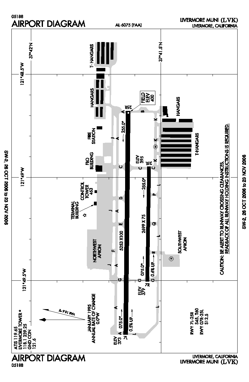
image-width =
caption =
IATA = LVK
ICAO = KLVK
type = Public
owner =
operator = City of Livermore
city-served =
location = Livermore, California
elevation-f = 400
elevation-m = 121.9
coordinates = Coord|37|41|36.2|N|121|49|13.3|W|type:airport|display=inline,title
website =
metric-elev =
metric-rwy =
r1-number = 7L/25R
r1-length-f = 5,253
r1-length-m = 1,601
r1-surface = Asphalt
r2-number = 7R/25L
r2-length-f = 2,699
r2-length-m = 823
r2-surface = Asphalt
stat-year =
stat1-header =
stat1-data =
stat2-header =
stat2-data =
footnotes = Livermore Municipal Airport Airport codes|LVK|KLVK is located in Livermore, California, USA, east of the San Francisco Bay between San Jose and Oakland. [cite gnis|1653611|Livermore Municipal Airport]
Sierra Academy of Aeronautics operated one of its training centers on the north ramp until December 2007. Other flight schools at Livermore Municipal Airport are Ahart Aviation Inc., Attitude Aviation and Red Sky Aviation.
History
The current terminal building was built in 1969.
References
ee also
*List of airports in the San Francisco Bay area
External links
* [http://www.ci.livermore.ca.us/airport/ Livermore Municipal Airport]
*
Wikimedia Foundation.
2010.
Look at other dictionaries:
Cloverdale Municipal Airport — IATA: none – ICAO: none – FAA LID: O60 Summary … Wikipedia
Petaluma Municipal Airport — sign outside Petaluma Municipal Airport IATA: none – ICAO: none – FAA LID: O69 Summary … Wikipedia
Healdsburg Municipal Airport — IATA: none – ICAO: none – FAA LID: KHES Summary Airport type Public Operator City of Healdsburg L … Wikipedia
Livermore (Kalifornien) — Livermore … Deutsch Wikipedia
Rio Vista Municipal Airport — IATA: none – ICAO: none – FAA LID: O88 Summary Airport type Public Operator City of Rio Vista Loca … Wikipedia
Livermore, California — For the California wine region, see Livermore Valley AVA. City of Livermore City … Wikipedia
Livermore Valley Joint Unified School District — Coordinates: 37°41′19.99″N 121°47′29.02″W / 37.6888861°N 121.7913944°W / 37.6888861; 121.7913944 … Wikipedia
San Francisco International Airport — SFO redirects here. For other uses, see SFO (disambiguation). This article is about the airport. For the BART Station servicing the airport, see San Francisco International Airport (BART station). For the television series, see San Francisco… … Wikipedia
San Jose International Airport — For the airport in San José, Costa Rica, see Juan Santamaría International Airport. Norman Y. Mineta San Jose International Airport IATA: SJC – ICAO: KSJC … Wikipedia
Marin County Airport — Gnoss Field IATA: none – ICAO: KDVO – FAA LID: DVO Summary Operator Marin County Location … Wikipedia