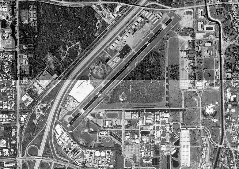
- Boca Raton Airport
Infobox Airport
name = Boca Raton Airport

image-width = 250
caption = 28 February 1999
IATA = BCT
ICAO = KBCT
FAA = BCT
type = Public
owner = State of Florida
operator = Boca Raton Airport Authority
city-served =Boca Raton, Florida
location =
elevation-f = 13
elevation-m = 4
coordinates = coord|26|22|43|N|080|06|28|W|region:US_type:airport_scale:10000
website =
r1-number = 5/23
r1-length-f = 6,276
r1-length-m = 1,913
r1-surface =Asphalt
stat-year = 2002
stat1-header = Aircraft operations
stat1-data = 91,004
stat2-header = Based aircraft
stat2-data = 205
footnotes = Source:Federal Aviation Administration FAA-airport|ID=BCT|use=PU|own=PU|site=03060.*A, effective 2007-12-20]Boca Raton Airport airport codes|BCT|KBCT|BCT is a state-owned public-use
airport located two miles (3 km) northwest of thecentral business district of Boca Raton, a city in Palm Beach County,Florida ,United States . The airport is immediately adjacent toFlorida Atlantic University and to Interstate 95.The Boca Raton Airport is publicly owned and is designated as a general aviation transport facility governed by a seven member Authority appointed by the City of Boca Raton and Palm Beach County Commission. [http://www.bocaairport.com/ Boca Raton Airport Authority] URL retrieved
April 5 2006 ]History
Beginnings
The Boca Raton Airport was established in 1936. In 1942, in response to the emerging Axis threat, the United States began to rapidly mobilize and expand its armed forces. In addition to enlarging its Army and Navy, the US also sought to expand its Air Force. The Air Force at this time was called the Army Air Corps, and was a subordinate program within the army. To expand the Air Corps, new bases were established throughout the United States, including bases in southern Florida at Homestead, Morrison Field in West Palm Beach, and at the Boca Raton Airport.cite web | last = | first = | title = The History of the Boca Raton Airport | work = | publisher = Boca Raton Airport Authority | url = http://www.bocaairport.com/history.shtml | accessdate =2006-10-21]
The Boca Raton Airport, also known as Boca Raton Army Airfield, was selected to house a military airfield for a number of geographic and practical reasons. Southern Florida's
climate and physical geography are generally considered mild compared to most northern locations. Florida experiences a winter climate characteristic of thesubtropics . Lacking snow or low temperatures enabled military operations to continue year round. Florida also has consistently flat terrain, an ideal feature when training new and inexperienced pilots. Its location adjacent to theAtlantic Ocean and theGulf of Mexico also provided ideal locations for flight training. Boca Raton was also chosen for practical purposes. In the early-1940s, Boca Raton's population numbered only 723. This enabled theUnited States government to take thousands of acres of land for its use without having to relocate a large number of people. However, this is not to say that the establishment of the military airfield was without controversy. A majority of the land was acquired fromJapanese-American farmers from the failing Yamato Colony. The land was seized through the process ofeminent domain , leaving many Japanese-Americans little recourse in the early days of World War II.cite web |title=The Yamato Colony: Japanese Pioneers in Florida |publisher=TheMorikami Museum and Japanese Gardens |url=http://www.morikami.org/index.php?src=gendocs&link=YamatoColony
accessdate=2006-11-04] All of these conditions enabled construction of the military airfield to commence in June 1942.cite web |title=A Journey Through Boca Raton: Timeline 1895 — 1999 |publisher=Boca Raton Historical Society |url=http://www.bocahistory.org/boca_history/br_history_timeline.asp |accessdate=2006-10-21]Recent history
In the 1950s part of the air base was developed into
Florida Atlantic University , and other parts were returned to private ownership and developed. Only 200 acres (0.8 km²) were retained for airport use.The airport suffered more than $12 million worth of damage to hangars when Hurricane Wilma passed through the area in October 2005.cite web |last=Moore |first=S. Clayton |title=Avitat Boca Raton Brings the Wow Factor to FBO Management |publisher=Airport Journals |url=http://www.airportjournals.com/Display.cfm?varID=0701005 |accessdate=2007-12-15] cite web |last=Valdemoro |first=Tania |title=Boca Airport Damage Hits $12 Million |publisher=Palm Beach Post |url=http://nl.newsbank.com/nl-search/we/Archives?s_hidethis=no&p_product=PBPB&p_theme=pbpb&p_action=search&p_maxdocs=200&p_field_label-0=Author&p_field_label-1=title&p_bool_label-1=AND&s_dispstring=hurricane%20wilma,%20boca%20raton%20airport,%20damages%20AND%20date(all)&p_field_advanced-0=&p_text_advanced-0=(hurricane%20wilma,%20boca%20raton%20airport,%20damages)&p_perpage=10&p_sort=YMD_date:D&xcal_useweights=no |accessdate=2007-12-15]Facilities and aircraft
Boca Raton Airport covers an area of 212
acre s (86 ha) and has oneasphalt pavedrunway designated 5/23 which measures 6,276 x 150 ft. (1,913 x 46 m). The airport has a control tower which is manned from 7:00am to 11:00pm. There are two full service fixed base operators, Avitat Boca Raton and Boca Raton Aviation. The Burton D. Morgan School of Aeronautic ofLynn University and a flight training school are located at the airport.For the 12-month period ending June 20, 2002, the airport had 91,004 aircraft operations, an average of 249 per day: 91%
general aviation , 9%air taxi and <1% military. At that time there were 205 aircraft based at this airport: 63% single-engine, 20% multi-engine, 16% jet and 1%helicopter .ee also
*
Florida World War II Army Airfields *
Fort Lauderdale-Hollywood International Airport References
External links
* [http://www.bocaairport.com/ Boca Raton Airport Authority]
*PDF| [http://www.cfaspp.com/FASP/AirportPDFs/boca_raton_%28july_2006%29.pdf Boca Raton Airport] |816 KiB brochure from [http://www.cfaspp.com/airports.asp CFASPP] (July 2006)
*FAA-diagram|00560
*FAA-procedures|BCT
*US-airport-ga|BCT
Wikimedia Foundation. 2010.
