- Sula, Møre og Romsdal
Infobox_Kommune
name=Sula
idnumber=1531
county=Møre og Romsdal
landscape=Sunnmøre
capital=Langevåg
governor=Ronny Harald Blomvik (Frp)
governor_as_of=2003
arearank=417
area=59
arealand=57
areapercent=0.02
population_as_of=2004
populationrank=135
population=7,342
populationpercent=0.16
populationdensity=128
populationincrease=8.4
language=Nynorsk
lat_deg=62| lat_min=25| lat_sec=29| lon_deg=6| lon_min=12| lon_sec=22
utm_zone=32V| utm_northing=6924617 |utm_easting=0355745| geo_cat=adm2nd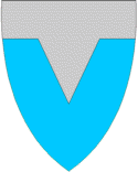
munwebpage=www.sula.kommune.no
Audio|Sula.ogg|Sula is a municipality and anisland in the county ofMøre og Romsdal ,Norway . It is also one of the most densely populated municipalities ofMøre og Romsdal . It should not be confused with the island Sula in the countySogn og Fjordane .The island of Sula was originally a part of Borgund municipality. Borgund was merged with
Ålesund January 1, 1968 - but the island of Sula was separated from Ålesund as a municipality of its own January 1, 1977.The name
The municipality is named after the island of Sula. The name is probably identical with the word "sula" f '
cleft '. (Referring to the cleft between the twin peaks of "Rundehornet" and "Vardane".)Coat-of-arms
The coat-of-arms is from modern times (1983). The figure represents the cleft of the island.
Geography
Sula is an island, bordered by
Breisundet on the west,Storfjorden andVartdalsfjorden to the south,Hessafjorden andBorgundfjorden to the north, and the narrowVegsundet strait to the east; the latter is bridged. The nature is typically coastal; forest is sparse, rock and heather dominate. The highest elevation, Vardane, is a locally speaking modest 776 m.a.s. Its neighbouring municipalities are all separated from it by sea;Hareid to the west,Ørsta to the south,Giske to the north-west andÅlesund to the north and east.The administrative centre is
Langevåg . Other centres includeSolevåg ,Fiskarstrand ,Veibust andMauseidvåg .Culture
Sula is noted for strong traditions in the field of music. Also, the community harbours a strong maritime heritage. The influence of neighbouring city
Ålesund is strong; many live in Sula while working in Ålesund.Economy
Manufacturing and production is the most important economical sector. Shipyards, fish processing, textile manufacturing and furniture production are especially vital.
Communication
Communication include the
E39 highway , which crosses the bridge at Vegsundet and continues to Solevåg; here, Sula is connected toØrsta by ferry. Also, Sula is connected toHareid by ferry atSulesund .
Wikimedia Foundation. 2010.