- Mare Smythii
-
Mare Smythii 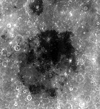
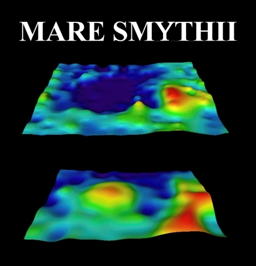
Mare SmythiiCoordinates 1°18′N 87°30′E / 1.3°N 87.5°ECoordinates: 1°18′N 87°30′E / 1.3°N 87.5°E Diameter 373 km (232 mi)[1] Eponym Sea of William Henry Smyth 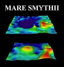 This figure shows the topography (top) and corresponding gravity (bottom) signal of Mare Smythii, revealing a mascon in its center.
Mare Smythii (Latin for "Sea of Smyth") is a lunar mare located along the equator on the easternmost edge of the lunar near side. The Smythii basin where the mare is located is of the Pre-Nectarian epoch, while the surrounding features are of the Nectarian system. The mare material, which make up the floor of the mare, is a high aluminous basalt, and consists of Upper Imbrian basalt covered by Eratosthenian basalt.
The crater Neper is located to the north of the mare. This crater makes up part of the southern rim of Mare Marginis. Just off to the northwest of the mare are the craters Schubert and Schubert B. The dark mare-filled crater at the southern edge of Smythii is the crater Kästner.
The Mare Smythii is named for the 19th century British astronomer William Henry Smyth.
References
- ^ "Moon Mare/Maria". Gazetteer of Planetary Nomenclature. USGS Astrogeology. http://planetarynames.wr.usgs.gov/SearchResults?target=MOON&featureType=Mare%2C%20maria. Retrieved 2010-08-20.
Lunar maria Mare Oceanus Lacus Sinus Paludes Categories:- LQ13 quadrangle
- Maria on the Moon

Wikimedia Foundation. 2010.