- Nsanje District
-
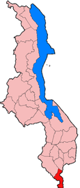
Nsanje is a district in the Southern Region of Malawi. The capital is Nsanje. The district covers an area of 1,942 square kilometres (750 sq mi) and has a population of 194,924.
Contents
Location
Nsanje is the southern most district in Malawi and lies in the Lower Shire River Valley. It straddles the Shire River in the north (the river forms most of Nsanje’s eastern boundary) and is surrounded by Mozambique. Elevation is around 200 feet (61 m) ASL except for some hills in the south-western part of the district which reach near to 2,000 feet (610 m) ASL. Mwabvi Game Reserve lies in the north-western part of the district and can be accessed from Bangula or Sorgin (both along the M-1 road) Elephant Marsh lies partially in the northern part of the district and can be accessed for tours via the eastern bank road. Tours start from the village of James.
Climate
Temperatures get as hot as 52 °C (126 °F) in November and around 8 °C (46 °F) in June. Rainfall averages around 750 millimetres (30 in) yearly coming January through April.
Economy
Nsanje is one of the poorest districts in Malawi and is virtually dependent on government and NGO aide organizations Major income comes from small holder farming. Maize, millet, sorghum, rice, and cotton are all grown using almost entirely rain fed agriculture.
Culture
The people of Nsanje are traditionally Sena people, or Mang'anja. The predominant language is Chichewa, but Chisena, Chimang’anja, English, and Portuguese are also spoken. A rain cult holds position south of Nsanje boma worshipping a deity called Mbona. His head was cut off hundreds of years ago and out flowed a river of blood. He now returns to his wife’s home every so often in the form of a python to tell prophecies for the coming year.
There are five National Assembly constituencies in Nsanje: Nsanje lalanje, Nsanje South West, Nsanje-Central, Nsanje-North and Nsanje-South. Since the 2009 election all of these constituencies have been held by members of the Democratic Progressive Party.[1]
References
 Regions and districts of Malawi
Coordinates: 16°45′S 35°10′E / 16.75°S 35.167°E
Categories:- Districts of Malawi
- Southern Region, Malawi
- Malawi geography stubs

Wikimedia Foundation. 2010.