Datchworth

Datchworth

Datchworth is a village and civil parish between the towns of Hertford, Stevenage and Welwyn Garden City in the county of Hertfordshire, England. Sited on the Roman road from St Albans to Puckeridge, the village has examples of Saxon clearings in several locations. Datchworth has a village green, two pubs (The Plough and The Tilbury) and a sports club.In the 2001 Census the population was 1,065.


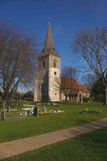
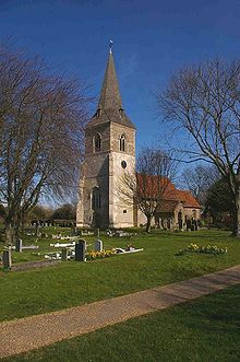
All Saints Church, Datchworth

The name Datchworth is thought to originate from a Saxon lord called Daecca (pronounced Datcher), who settled here around the year 700 AD. 'Worth' comes from the word Wyrthe, which means enclosure.

However, Datchworth was certainly occupied well before 700 AD. There are two large Belgic sites, only one of which has been partly investigated. Much of the parish boundary still follows the old Belgic ditches.

The arrival of the Normans gave Datchworth a written record in the Domesday Book. This included an account of the occupants and land values in the 11th century.

Standing at the eastern side of Datchworth Green is the whipping post. Its last recorded use was on 27 July 1665 when two 'vagabonds' were publicly flogged. Stocks stood near the post too, but there is no trace of them now. The stocks are thought to have been removed in 1899.

During the Second World War the last enemy-action incident of any kind on British soil occurred at 09:00 on 29 March 1945 when a V-1 flying bomb struck a nearby field.[1]

References

  1. ^ King, Benjamin; Timothy Kutta (2003). Impact: The History of Germany's V-Weapons in World War II. Da Capo Press. p. 309. ISBN 0306812924. 

External links

Coordinates: 51°51′N 0°09′W / 51.85°N 0.15°W / 51.85; -0.15


Wikimedia Foundation. 2010.

Игры ⚽ Поможем написать реферат

Look at other dictionaries:

  • 2006 - 2007 English Colts Club Knockout Cup — The 2006/2007 English Colts Club Knockout Cup Competition was run for the 10th season between September 2006 May 2007. A record number of teams competed, with Bedford winning the Cup and Bury St Edmunds winning the Plate at Franklin s Gardens,… …   Wikipedia

  • List of museums in England — Museums in England is a link page for any museum in England by ceremonial county. The Museums, Libraries and Archives Council is the national development agency for museums in England, and is a sponsored body of the Department for Culture, Media… …   Wikipedia

  • Operation Crossbow — Opération Crossbow L Opération Crossbow (en français, « Opération Arbalète ») est une série d opérations de bombardement aérien, effectuées par les Alliés pendant la Seconde Guerre mondiale, contre les rampes de lancement de V1 de… …   Wikipédia en Français

  • Opération Crossbow — L Opération Crossbow (en français : « Opération Arbalète ») est une série d opérations de bombardement aérien, effectuées par les Alliés pendant la Seconde Guerre mondiale, contre les rampes de lancement de V1 de décembre 1943 …   Wikipédia en Français

  • Opération arbalète — Opération Crossbow L Opération Crossbow (en français, « Opération Arbalète ») est une série d opérations de bombardement aérien, effectuées par les Alliés pendant la Seconde Guerre mondiale, contre les rampes de lancement de V1 de… …   Wikipédia en Français

  • V-1 flying bomb — Buzzbomb redirects here. For the song by the Dead Kennedys, see Buzzbomb (song). For other uses, see V1 (disambiguation). V 1 flying bomb Fieseler Fi 103 Flakzielgerät 76 (FZG 76) V 1 flying bomb …   Wikipedia

  • Stevenage — For other uses see Stevenage (disambiguation) Borough of Stevenage   Non metropolitan district   …   Wikipedia

  • Knebworth — Coordinates: 51°51′58″N 0°11′02″W / 51.866°N 0.184°W / 51.866; 0.184 …   Wikipedia

  • List of civil parishes in Hertfordshire — This is a list of civil parishes in Hertfordshire, England.Broxbourne none DacorumHemel Hempstead is unparished.* Aldbury * Berkhamsted * Bovingdon * Chipperfield * Flamstead * Flaunden * Great Gaddesden * Kings Langley * Little Gaddesden *… …   Wikipedia

  • Stevenage (UK Parliament constituency) — UK constituency infobox Name = Stevenage Map1 = Stevenage Map2 = Hertfordshire Type = County Year = 1983 Entity = Hertfordshire County = Hertfordshire EP = East of England MP = Barbara Follett Party = LabourStevenage is a constituency represented …   Wikipedia

Share the article and excerpts

Direct link
Do a right-click on the link above
and select “Copy Link”