- Chandeleur Islands
-
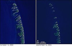 The left image is from 2004 and the right is after Hurricane Katrina, showing the reduction of the islands.
The Chandeleur Islands (French: Les Îles de Chandeleur) are a chain of uninhabited barrier islands approximately 50 miles (80 km) long, located in the Gulf of Mexico. They form the easternmost point of the state of Louisiana, USA and are a part of the Breton National Wildlife Refuge. They are an important migrating point for many birds on their way south, and are a prime marsh and forest wildlife area.
Contents
History
The islands were formed over two thousand years ago as the rim of the St. Bernard Lobe of the Mississippi River delta.[1]
The islands were named when explorer, Pierre Le Moyne d'Iberville, was sailing in search of the mouth of the Mississippi River along the Gulf Coast. He christened the islands on the eve of La Fête de la Chandeleur, a Christian day of observance, on February 1, 1700.[2]
The Breton National Wildlife Refuge was established in 1904 and includes all of the Chandeleur Islands in the Gulf of Mexico. The refuge is the second-oldest in the National Wildlife Refuge System.
Prior to destruction by a hurricane in 1915 there was a fishing settlement on the islands, and even earlier there had been farming on the islands. The Chandeleur Island Light, built in 1895, stood as a landmark and recognizable location for mariners at sea and pilots flying over the Gulf of Mexico.[3] The islands, were constantly eroded and changed by wave action, and most dramatically after the storm surges following hurricanes.
The islands have been generally shrinking and migrating landward since the late 19th century. A survey in the 1980s estimated that they would be in existence for about three more centuries. Before 1996, the seaward front of the islands lost about 20–30 feet of land each year, mostly replaced at the rear. From 1996 to 2004, the loss rate grew to about 300 feet (91 m) per year. In 1998, Hurricane Georges destroyed the islands and left the lighthouse in the middle of the ocean, and the barrier islands only just recovered when Hurricane Katrina struck in 2005.
However, the combined effect of Hurricane Dennis and Hurricane Katrina in 2005 reduced the island to shoals or sub-surface formations, and toppled the Chandeleur Island Light. Powerful storms can produce changes that would otherwise have taken many years. A study released in 2006 by geologists from the University of New Orleans shows that the usual sand and sediment patterns that rebuilt the islands after big storms have not been restored since Katrina reworked the area. There is also evidence of unprecedented landslides on the seafloor on the side toward the Gulf of Mexico, potentially allowing stronger waves with greater erosional impact to reach the islands. If the islands recover, it may take generations. If movements of sand and sediment do not restore the islands, they may be gone in a decade.
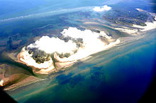 Deepwater Horizon oil spill slicks surround the Chandeleur Islands in this aerial photo.
Deepwater Horizon oil spill
The ecosystem on the islands is further threatened by the Deepwater Horizon oil spill in the Gulf of Mexico. On May 6, 2010, the oil sheen reached the islands' shores and the wildlife refuge.[4]
References
- "Chandeleur Islands". NASA Earth Observatory. http://earthobservatory.nasa.gov/Newsroom/NewImages/images.php3?img_id=17055. Retrieved 2006-05-03.
- "Chandeleur Islands said not rebuilding". Boston.com. August 2, 2006. http://www.boston.com/news/science/articles/2006/08/02/chandeleur_islands_said_not_rebuilding/. Retrieved 2006-08-03.
- "Study: Katrina, Rita may have KO’d islands: Scientists fail to find Chandeleur’s sandy start to rebuilding". http://www.texasrodbenders.com/discus/messages/25823/27118.html?1154656520.
- ^ Pilkey, Orrin H.; Mary Edna Fraser (2003). A Celebration of the World's Barrier Islands. Columbia University Press. p. 120. ISBN 0231119704.
- ^ http://www.lighthousefriends.com/light.asp?ID=810
- ^ "Historic Light Station Information and Photography: Louisiana". United States Coast Guard Historian's Office. http://www.uscg.mil/history/weblighthouses/LHLA.asp.
- ^ Deepwater Horizon Rig Disaster - TImeline - wsj.com - Retrieved June 3, 2010[dead link]
External links
Coordinates: 29°50′09″N 88°50′04″W / 29.83583°N 88.83444°W
Categories:- Islands of Louisiana
- Geography of Plaquemines Parish, Louisiana
- Geography of St. Bernard Parish, Louisiana
- Deepwater Horizon oil spill


Wikimedia Foundation. 2010.