- Deansgate
-
This article is about Deansgate, Manchester city centre. For Deansgate, Bolton, see Bolton.
Deansgate 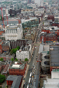
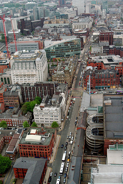
Aerial view of Deansgate from the Beetham Tower Road number  Part of the A56 road
Location Manchester, UK Length 0.8 miles (1.3 km) Direction North-south Start Castlefield End Victoria Street Landmarks Kendals, the Great Northern Warehouse, the John Rylands Library, Beetham Tower, Manchester Cathedral Known for Shopping Passes through Central Manchester Deansgate is a main road (part of the A56) through the city centre of Manchester, England. It runs roughly north–south in a near straight route through the western part of the city centre and is the longest road in the city centre at over one mile long.[1]
Contents
History and geography
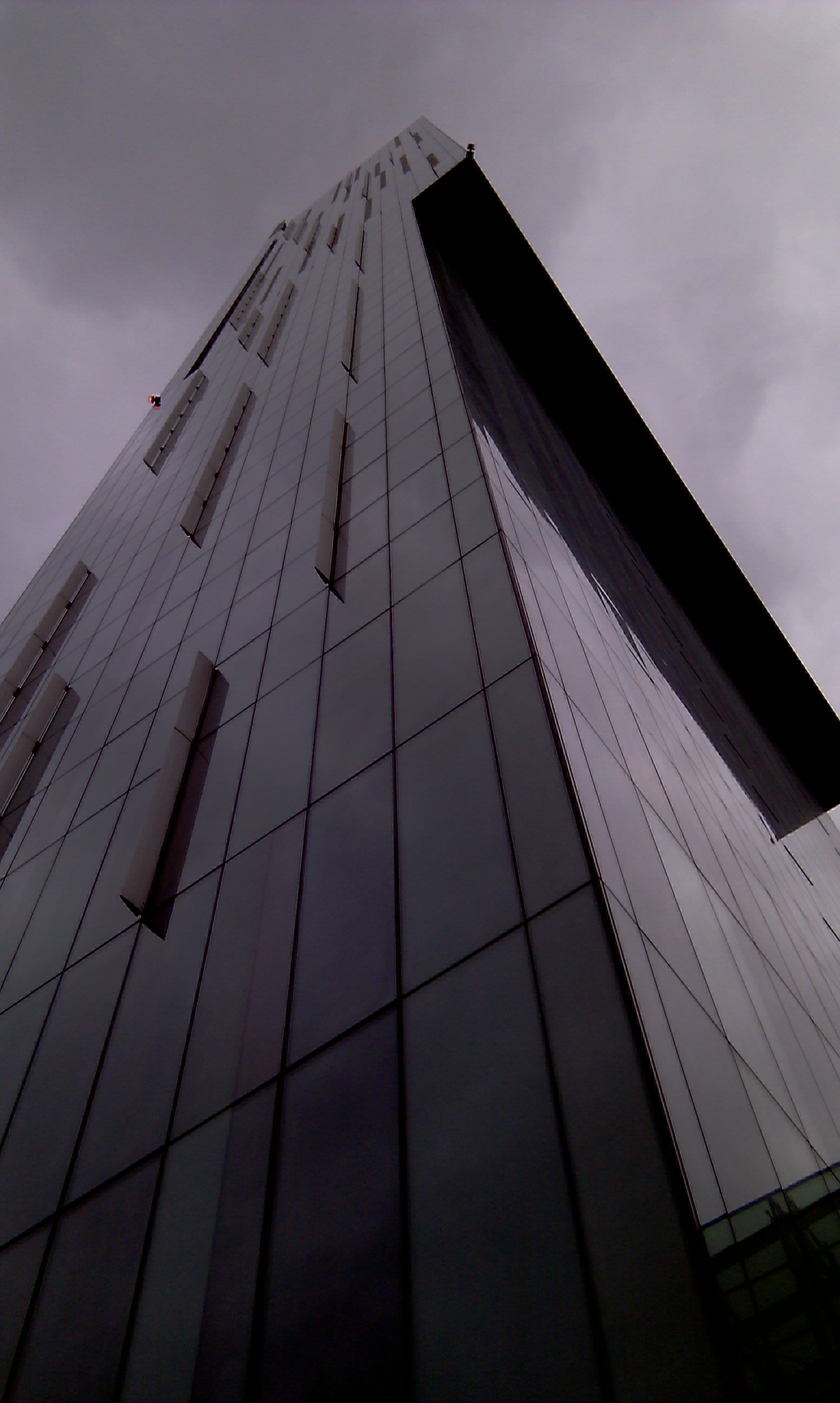
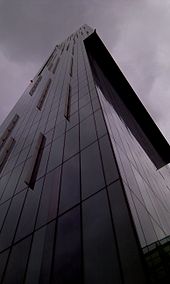 Beetham Tower, the tallest building in the United Kingdom outside London
The road is named after the lost River Dene, which may have flowed along the Hanging Ditch connecting the River Irk to the River Irwell, at the northern end of Deansgate.[2] ("gate" derives from the Norse gata, meaning way). It begins now at Victoria Street but that street was a 19th-century creation: at the time the east side of Deansgate was occupied by Victoria Buildings (built by Manchester Corporation in 1876 but ruined during a bomb raid in December 1940 during the Second World War) on a triangular site[3] (later a statue of Oliver Cromwell was placed at the northern corner commemorating Manchester's support for Parliament in the English Civil War). The statue was a gift to the city by Mrs. Abel Heywood in memory of her first husband Thomas Goadsby; it was the first large statue of Cromwell to be raised in the open anywhere in England.[4]
At the northern end of Deansgate it becomes Victoria Street, on which lies Manchester Cathedral, and at the southern end is Deansgate railway station. At this point Deansgate connects with Bridgewater Viaduct and Chester Road (Whitworth Street West also meets it at this point). The section to the south of Peter Street was until the end of the 18th century known as Aldport Street[5] (Aldport being the former name of the Castlefield area once separate from medieval Manchester).
It contains many shops including a House of Fraser department store (known as Kendals from the 1830s until 2005), and opposite this the booksellers Waterstones along with many public houses and bars including The Moon Under Water, formerly the Deansgate Cinema (or ABC Deansgate). At 820 square metres (8,800 sq ft), able to accommodate 1,700 customers, and employing 60 staff, it has been listed in The Guinness Book of Records as the largest public house in Britain.[6] Elliot House was once the Manchester Registry Office and before that the offices of the Corporation's Education Department.
The northern end of the street used to adjoin a retail area known as The Shambles. This was badly damaged in the IRA bombing in 1996. The area was eventually redeveloped and is home to several new buildings, including No. 1 Deansgate and the Manchester branch of Harvey Nichols. Other recent additions to the Deansgate area include the Royal Bank of Scotland building, the Beetham Tower, and the redevelopment of the Great Northern Warehouse. These stand in contrast with historic buildings, such as the John Rylands Library and the Barton Arcade shopping mall. The disused Manchester and Salford Junction canal runs directly underneath Deansgate and below the Great Northern Warehouse.
By the late 19th century Deansgate had changed into an area of very varied uses: the northern end had shopping and substantial office buildings while further south were notorious slums and a working class area around St John's Church (St John Street remaining upper middle class). The Wood Street Mission began to address the social problems in 1869 and its work still continues in a very different form.[7] From Peter Street southwards the eastern side was dominated by the viaducts of the Great Northern and Manchester South Junction Railways, while the Rochdale Canal crossed below Deansgate to connect with the other waterways beyond.
In the late 20th century it was home to the head office of the Manchester Evening News newspaper, since replaced by part of the Spinningfields development.
Events
 Jenson Button drives a McLaren F1 car down Deansgate
Deansgate is noted for its long straight, which provides an ideal route for sporting events in the heart of the city. In 2006 A1 Racing cars visited the city to launch A1 Grand Prix, and used Deansgate as part of the street route.[8] In August 2011 thousands packed the street as Jenson Button drove a McLaren MP4-23 along Deansgate as part of the Vodafone Vip Live Manchester festival.
In 2009 the inaugural Great City Games took place on Deansgate, which featured a 150-metre sprinting track down Deansgate. The event has since become an annual fixture which occurs on the Great Manchester Run weekend during mid-May. Usain Bolt set a world record for the 150 m straight in 2009 and Tyson Gay ran another for the 200 m straight in 2010.[9][10]
Transport
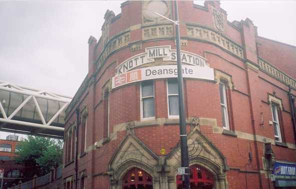
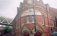 Deansgate railway station: station frontage which features the previous "Knott Mill" name
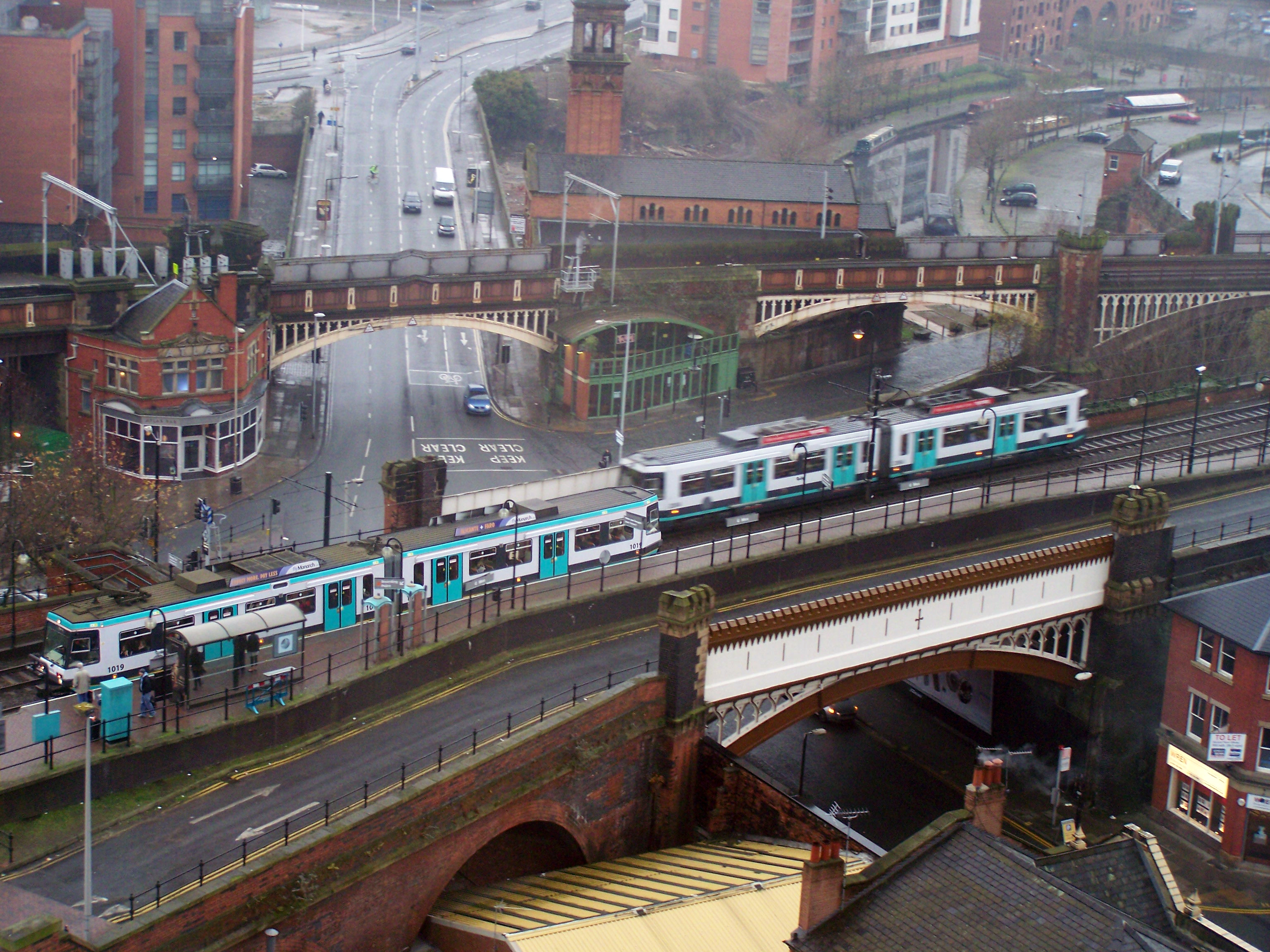
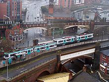 Deansgate-Castlefield Metrolink stop on the viaduct crossing Deansgate
Deansgate was for the first half of the 20th century an important tram route and subsequently carried numerous bus services. During the 1970s many of these were diverted elsewhere or separated into two services terminating in the City Centre and adjoining streets such as King Street were pedestrianised.
Today, the main transport links on Deansgate are the National Rail and Metrolink stations which lie at its northern and southern ends:
- Manchester Victoria
- Deansgate
- Deansgate-Castlefield Metrolink station
Deansgate is served by a number of bus routes, including the Metroshuttle services.
As it is one of the main roads that connects the northern and southern areas of Manchester, Deansgate has a great deal of traffic, and the many shops, pubs and bars ensure it is busy with pedestrians both during the day and late into the night.
In 2009 there were calls for traffic to be banned on Deansgate and for it to be pedestrianised.[11] The calls were triggered in response to road works which closed parts of Deansgate. Some argue that the disablement of a major traffic route in Manchester could have a damaging economic effect[12] for the city whilst others argued a vehicle-free Deansgate would attract more shoppers.
References
Notes
- ^ "Manchester Deansgate Bars". manchesterbars.com. http://www.manchesterbars.com/location-deansgate.htm. Retrieved 4 August 2011. "Located at the top end of Deansgate, the mile long road that runs through the city centre"
- ^ Cooper (2003), p. 52
- ^ There were 31 shops on the ground floor of Victoria Buildings and many offices on the floors above. Victoria Arcade ran through the block and at the northern end was the Victoria Hotel (100 rooms).
- ^ Hardy, Clive (2000) Francis Frith's Greater Manchester. Salisbury: Francis Frith Collection; p. 67-69, 71
- ^ Laurent (1793) "Plan of Manchester and Salford illustrated", in: Bradshaw (1985), p. 20
- ^ Parkinson-Bailey (2000), p. 287.
- ^ Heaton (1995)
- ^ "Race cars roar down city streets". Manchester Evening News. 14 August 2006. http://menmedia.co.uk/manchestereveningnews/news/s/220580_race_cars_roar_down_city_streets. Retrieved 2011-08-22.
- ^ Bolt runs 14.35 sec for 150m; covers 50m-150m in 8.70 sec!. IAAF (2009-05-17). Retrieved on 2011-09-14.
- ^ Tyson Gay breaks Tommie Smith's 200m mark in Manchester. BBC Sport (2010-05-16). Retrieved on 2011-09-17.
- ^ "Should traffic be banned from Deansgate?". Manchester Evening News. 24 August 2009. http://www.manchestereveningnews.co.uk/news/s/1133189_should_traffic_be_banned_from_deansgate.
- ^ Thompson, Dan (25 August 2009). "Deansgate car ban 'could kill city centre'". Manchester Evening News. http://www.manchestereveningnews.co.uk/news/s/1133369_deansgate_car_ban_could_kill_city_centre.
Bibliography
- Cooper, Glynis (2003). Hidden Manchester. Breedon Books Publishing. ISBN 1-85983-401-9.
- Heaton, Frank (1995). The Manchester Village: Deansgate remembered. Radcliffe: Neil Richardson.
- Parkinson-Bailey, John J. (2000). Manchester: An Architectural History. Manchester University Press. ISBN 0-7190-5606-3.
Further reading
Categories:- Streets in Manchester
- Shopping streets in Manchester
- Visitor attractions in Manchester

Wikimedia Foundation. 2010.