Karatal River

Karatal River

Infobox River
river_name = Karatal River


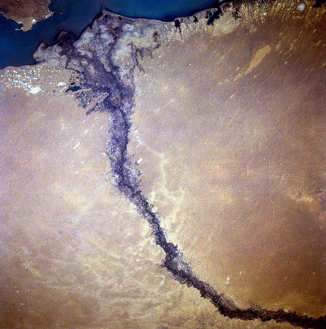
caption = Karatal River entering Lake Balkhash as seen from space, September 1996 -North at bottom
origin = Dzungarsk-Alatau Mountains
mouth = Lake Balkhash
basin_countries = Kazakhstan
length = 390 km
elevation =
discharge =
watershed = 19,100 km²

The Karatal River ( _ru. Каратал) is the easternmost of the two large rivers that flow into Lake Balkhash, the other being the Ili River. It rises in the Dzungarian Alatau Mountains near the border of Kazakhstan and China. The river flows generally northwestward turning generally northward when it reaches the Saryesik-Atyrau Desert, a large sand desert south of Lake Balkhash. The river empties into Lake Balkhash near its center. Karatal freezes up in December and stays icebound until March.

References

* "Great Soviet Encyclopedia"
* National Aeronautics and Space Administration


Wikimedia Foundation. 2010.

Игры ⚽ Поможем сделать НИР

Look at other dictionaries:

  • Río Karatal — (Каратал) Vista del lago Baljash (agosto 2000). Puede observarse el cauce del Karatal en la parte central de la imagen. País que atraviesa …   Wikipedia Español

  • Chu River — Coordinates: 44°59′N 67°43′E / 44.983°N 67.717°E / 44.983; 67.717 …   Wikipedia

  • Arys River — The Arys is a river of southern Kazakhstan and a tributary of the Syr Darya. The length of the river is 378 km, covering a basin area of 14,900 km2. The river begins in the Talas Alatau ridge, and average water flow is 46.6 m 3 / sec. The… …   Wikipedia

  • Asa River (Kazakhstan) — The Asa River is a river of Kazakhstan. v · …   Wikipedia

  • Charyn River — near Charyn Canyon The Charyn River is a river in the Almaty Province of Kazakhstan. It flows into the Ili River, which is considered to be the largest artery of Lake Balkhash. The Charyn River is 427 km long. It runs through the territory… …   Wikipedia

  • Narym River — Narym Origin Kazakhstan Mouth Buhtarma Reservoir, Irtysh Basin countries Kazakhstan Length km Avg. discharge m³/s (near mouth) …   Wikipedia

  • Nura River — Coordinates: 50°20′34″N 69°08′21″E / 50.34278°N 69.13917°E / 50.34278; 69.13917 …   Wikipedia

  • O River — The O River is a river of Kazakhstan. v · …   Wikipedia

  • Lake Balkhash — Not to be confused with Lake Baikal. Lake Balkhash Балқаш Көлі Озеро Балхаш View from Space, April 1991 Location Kazakhstan Coordinates …   Wikipedia

  • List of rivers of Kazakhstan — Rivers of Kazakhstan include:*Aksu River *Byan River *Chu River *Emba River *Ilek River *Ili River *Irtysh *Ishim River *Kapal River *Karatal River *Koksu River *Syr Darya *Talas River *Tobol River *Tuolba River *Turgai River *Ural River …   Wikipedia

Share the article and excerpts

Direct link
Do a right-click on the link above
and select “Copy Link”