Ruth Glacier

Ruth Glacier

Infobox_Glacier | glacier_name = Ruth Glacier


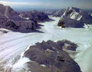
caption = Ruth Glacier
type = Valley glacier
location = Matanuska-Susitna Borough, Alaska, U.S.
coordinates = coord|62|47|05|N|150|38|37|W|type:glacier
area =
length = 40 miles (64 km)
thickness = 3,800 feet (1,158 m) (1983)
terminus = moraine
status = unknown

Ruth Glacier is a glacier in Denali National Park and Preserve in the U.S. state of Alaska. [cite web| url = http://www.topozone.com/map.asp?lat=62.7847&lon=-150.64372&s=500&size=l&u=4&datum=nad27&layer=DRG| title = USGS Talkeetna D-2 (AK) Topo Map| publisher = Topozone| accessdate = 2007-01-25] Its upper reaches are almost three vertical miles (4.8 km) below the summit of Mount McKinley. The glacier's "Great Gorge" is one mile (1.6 km) wide, and drops almost 2,000 feet (600 m) over ten miles (16 km), with crevasses along the surface. Above the surface on both sides are 5,000-foot (1,500-m) granite cliffs. From the top of the cliffs to the bottom of the glacier is a height exceeding that of the Grand Canyon. Ruth Glacier moves at a rate of 3.3 feet (1 m) a day and was measured to be 3,800 feet (1,158 m) thick in 1983. [cite web| url =http://www.nps.gov/dena/naturescience/ruth_glacier.htm| title = Ruth Glacier|work=Denali National Park and Preserve| publisher = National Park Service| accessdate = 2007-01-25]

Surrounding the Ruth Gorge are many mountains of the Alaska Range, including the Mooses Tooth, with highly technical ice and rock climbs on their faces.

ee also

* List of glaciers

Cited references


Wikimedia Foundation. 2010.

Игры ⚽ Нужен реферат?

Look at other dictionaries:

  • Ruth Glacier — Der Ruth Gletscher Der Ruth Gletscher ist ein Gletscher in der Alaskakette in Alaska. Er ist 50 km lang und liegt im Denali Nationalpark …   Deutsch Wikipedia

  • Inter Glacier — Infobox Glacier | glacier name = Inter Glacier caption = type = Mountain glacier location = Mount Rainier, Washington, U.S. coordinates = coord|46|52|35|N|121|43|37|W|type:glacier [Google Earth images.] area = 0.3 mile² (0.8 km²), 1983 length =… …   Wikipedia

  • Mount Ruth — (86°18′S 151°45′W / 86.3°S 151.75°W / 86.3; 151.75) is a ridge shaped mountain, 2,170 m, standing 3 nautical miles (6 km) west of Mount Gardiner, at the southeast side of the lowe …   Wikipedia

  • Mount McKinley — Denali redirects here. For other meanings, see Denali (disambiguation). Mount McKinley Denali Mount McKinley from the north. Wonder Lake is in the foreground …   Wikipedia

  • Золотой ледоруб — (фр. Piolet d Or, англ. The Golden Ice Axe)  международная награда за выдающиеся достижения в альпинизме, присуждаемая ежегодно французским журналом Montagnes и The Groupe de Haute Montagne (GHM) с 1992 года.[1] …   Википедия

  • Jim Bridwell — (born 1944) is a noted American rock climber and mountaineer, active since 1965 especially in Yosemite Valley, but also in Patagonia and Alaska. He is noted for pushing the standards of both free climbing and big wall climbing, and later alpine… …   Wikipedia

  • Mount Huntington (Alaska) — Mount Huntington Elevation 12,240 ft (3,731 m) Prominence 2,890 ft (881 m) …   Wikipedia

  • Fake Peak — is a small outcrop on a ridge beside the Ruth Glacier in Denali National Park and Preserve in Alaska, USA, 19 miles southeast of the summit of Mount McKinley. It has been shown by Robert M. Bryce that the summit photograph produced by Frederick… …   Wikipedia

  • Piolet d'Or — The Piolet d Or (French for The Golden Ice Axe ) is an annual mountaineering award, given by the French magazine Montagnes and The Groupe de Haute Montagne since 1991. Nominations are selected by GHM and Montagnes , and the award is chosen by a… …   Wikipedia

  • Clark Reservation State Park — Glacier Lake and the cliff of the fossil waterfall in September. Clark Reservation State Park is a state park in Onondaga County, New York. The park is in the Town of DeWitt, south of Syracuse. It wa …   Wikipedia

Share the article and excerpts

Direct link
Do a right-click on the link above
and select “Copy Link”