- Rionegro, Antioquia
Infobox City
name = Rionegro
native_name =Santiago de Arma de Rionegro
nickname =
motto = Cuna de la democracia (Cradle of Democracy)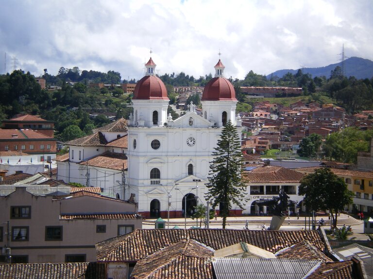
imagesize = 300px
image_caption =Catedral de San Nicolás el Magno 
image_
mapsize = 250px
map_caption = Location of the city (Marked in red) in the Antioquia region of Colombia
pushpin_
pushpin_mapsize =300
pushpin_map_caption =Location in Colombia
subdivision_type = Country
subdivision_name = flag|Colombia
subdivision_type1 =Departamento
subdivision_name1 =Antioquia
subdivision_type2 =Region
subdivision_name2 =Eastern Antioquia
leader_title = Mayor
leader_name = Hernan de Jesús Ospina
established_title =
established_date =
area_magnitude =
area_total_km2 =
area_total_sq_mi =
area_land_km2 =
area_land_sq_mi =
area_water_km2 =
area_water_sq_mi =
area_water_percent =
area_urban_km2 =
area_urban_sq_mi =
area_metro_km2 =
area_metro_sq_mi =
population_as_of = 2005
population_note =
population_total = 101,046
population_density_km2 = 466
population_density_sq_mi =
population_metro =
population_density_metro_km2 =
population_density_metro_sq_mi =
population_urban =
latd=6 |latm=9 |lats=18 |latNS=N
longd=75|longm=23|longs=20 |longEW=W
timezone =
utc_offset =
timezone_DST =
utc_offset_DST =
elevation_m = 2125
elevation_ft =
website = [http://www.rionegro.gov.co/ Government of Rionegro official website]
footnotes =Rionegro is a
city and municipality inAntioquia Department ,Colombia , located in the subregion ofEastern Antioquia . The official name of the municipality is "Santiago de Arma de Rionegro" but is named after theNegro River which is the most prominent geographical feature of the municipality. Rionegro is also sometimes called the "Cuna de la democracia" (Cradle of democracy) as it was one of the most important cities during the era of the Colombia's struggle for independence and the 1886 constitution was written in the town.History
The territory was first mentioned in
1541 byAlvaro de Mendoza . When the CaptainJorge Robledo took possession of the Valley of Aburrá, he was commissioned by Alvaro de Mendoza. According to Fray Pedro Simón, Robledo was the firstIberian man who discovered the Valley of Rionegro on September 2 of 1541. Don Juan Daza, a Spaniard of illustrious lineage, took possession of the lands sometime later, and on the 8th of November of1581 , in agreement with the rituals of the laws of Indians,nailed his sword in the ground marking it has an inhabited place and began constructing a farm.Immigration to Rionegro came from numerous regions of the country, including from the same provincial capital of the time,
Santa Fe de Antioquia and the original ranch grew into a village and then a town in the first half of the 17th century. The chapel,Concatedral de San Nicolás el Magno , consecrated toSaint Nicholas was built as early as1642 , another reason why the territory reached a greater degree of independence for religious reasons. In1783 , Rionegro had became like a municipality, resulting in becoming the City of Santiago de Arma de Rionegro in1786 , with administative powers under certification of KingCarlos III , issued in the Palace of San Idelfonso on the 25th of September 1786.Rionegro grew in the nineneeth century and was an important center during the time it was a Spanish colony, and in the early years of Independence. The city then revalled
Santafé de Antioquia to compete for the capital of Antioquia, until the city ofMedellín grew prominently and far exceeded the growth of these cities.Geography
The municipality of Rionegro is located in the central mountain range of the
Andes in eastern Antioquia. With a total area of 196 km², is part of the sub-region ofEastern Antioquia . The city is surrounded in the north by the municipalities ofGuarne and SanVicente , in the east by the municipalities ofMarinilla andEl Carmen de Viboral , in the south by the municipality ofLa Ceja , and in the west by the municipalities ofEl Retiro andMedellin .The city of Rionegro is located at coor dms |6|9|18|N|75|22|48|W|, at an average elevation of 2,125 metres above sea level. The average annual
precipitation varies between 1,800 and 2,500 millimeters with an average temperature of 17°C. Much of the land consists of volcanic ashes and soils with a high resistance to the erosion.The altitude of the rest of the territory varies between the 2,100 and the 2,600 metres, and the topography is characterised by a number of small hills, some of which may rise to a greater height and slope like Cerro del Capiro, located in limits with the municipality of La Ceja. A sharper mountainous system emerges towards the West of the municipality, which becomes a physical barrier between the Valley of the Aburrá and the Plateau of Rionegro, from where the main affluents of the
Negro River are born. The main hills of the mountainous chain that surround the Valley by Rionegro are: Alto Gordo, Alto de Amariles, Alto de Salazar o La Pilastra, Cerro Verde, Alto de Careperro, Alto de Pantanillo, Cerro Corcovado and Cerro del Capiro.Part of the municipality is an
alluvial plain of the Negro River and its tributaries, which also include thePantanillo Rive r and the gorges such as Las Palmas and Espíritu Santo y Fizebad.Historically the Negro River divided the valley in two, with the Valley of Llanogrande and the Valley of San Nicholas.Hydroelectric companies operate in the area, and have constructed a Hydroelectric Power station at Guatapé with theSanta Rita Dam . Today the hydroelectric complex of Eastern Antioquia consists of five power stations, two of which are public companies ofMedellín city.Demographics
According to the figures presented by the
National Administrative Department of Statistics (DANE) in the2005 census, the municipality of Rionegro had a total population of 101,046 inhabitants, the sixth largest populated area in Antioquia. cite web|url=http://www.dane.gov.co/files/censo2005/perfiles/perfiles.swf|title=Rionegro, Antioquia, Perfiles Departamentos y Municipios, Official Census 2005|date=2005|publisher=Departamento Administrativo Nacional de Estadística|accessdate=October 11|accessyear=2008]The municipality had a
population density of approximately 466 inhabitants per square kilometer. The ethnicity of the population is almost entirely ofMestizo andWhite persons (98.9%) with 1.1%Afro Colombian . 48.6% of the population are men and 51.4% women and city had a rate of 5.7% who wereilliterate , but most of these were under 5 years of age and not yet eligible or mature enough for an education. Public services in Rionegro are of a relatively high standard with 98.7% of houses supplied withelectricity , 95.6% with awater supply and 87.1% with atelephone connection.Administration
Rionegro is governed by a democratic system based on the processes of administrative decentralization generated by the proclamation of Political constitution of Colombia in
1991 . For the city there is a mayor with executive authority and a Municipal Council with legislative rights. The Mayor of Rionegro is naturally the head of the local government and the municipal administration, representing legal, judicial authority in the municipality. The position of mayor is chosen by popular vote for a period of four years, that at present is a position held byAlcides Tobón Echeverri . Amongst his main functions are the administration of the resources of the municipality including responsibility of health, housing, education and road infrastructure, to guard the well-being and respond to the interests of his fellow citizens and to represent them before the National Government, besides being impelled to implement local policies to improve quality of life within the municipality.The Municipal council of Rionegro, is also subject to election, composed by 17 politicians of varying political parties, chosen for a period of four years. The council is the associated executive organization of the municipality with obligation to take responsibility for Rionegro's territorial jurisdiction. Amongst its functions are approving the proposals and projects of the mayor, and with financial obligation to draw up the
budget and to take responsibility of collectingrent s andtax es. Administratively the Mayorship of Rionegro is divided in two main groups, the chief central administration and the decentralized organizations. These organizations are denominated Secretaries, whose main objective is the benefit of services to the community.Economy
The local economy is based on
industry .Agriculture also plays an important role in the local economy, the main activities beingflower s, and cattle ranching and poulty. In recent yearstourism has become one of the main sources of income in the area.Transport
Rionegro has a private system of
bus es that cater for all the sectors of the municipality and have bus routes throughout the municipality which connect it toMedellín . Taxis are also well used in the urban area. located within Rionegor municipality isJosé María Córdova International Airport that serves Medellín. Domestic flights, international flights and connections with other aerial terminal of the world are made possible via this airport.ites of interest
*Concatedral de San Nicolás el Magno -built in the 1790s and opened in 1804.
*Parque principal La Libertad
*Museo de Arte Religioso
*Calle de la Madera
*Tutucán
*Parque Los Osos Comfama de Rionegro
*Casa de La Convención
*Puente Mejía*Palacio de la Cultura Ricardo Rendón
*Corregimiento San Antonio de Pereira
*Casa de La Maestranza
*Parque de San Antonio de Pereira
*Iglesia de San Antonio de Pereira
*Antiguo Colegio de Rionegro
*Iglesia de San Francisco
*Iglesia de Jesus Nazareno
*Archivo Historico de Rionegro
*Estatua Ecuestre del General José María Cordova
*Cementerio Principal
Religion
*
Roman Catholic Diocese of Sonsón–Rionegro ports
The town is home to the
Deportivo Rionegro football soccer team. FOunded in 1939, they play their home games at theEstadio Alberto Grisales .References
:"this article incorporates text translated from Spanish wikipedia"


Wikimedia Foundation. 2010.