OziExplorer

OziExplorer
OziExplorer
Oziexplorer logo.gif
Oziexplorer screenshot.gif
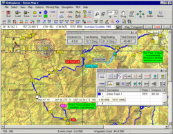
Developer(s) D & L Software Pty Ltd Australia
Stable release 3.95.5m / August 16, 2011; 60 days ago (2011-08-16)
Operating system Microsoft Windows
Type GPS navigation software
License Shareware/Demo and Trial
Website www.oziexplorer.com

OziExplorer is raster navigation and mapping software for Windows. It is very popular among off-road drivers and adventure travelers as it allows to use and create custom maps for remote locations that are not fully covered by major map providers like Tele Atlas. That is why the software is also widely used on Post-Soviet states territory.

It supports editing, uploading and downloading of waypoints, routes and tracks to most Garmin, Magellan, Lowrance, Brunton and MLR GPS devices.[1]

OziExplorer provides support for Google Maps, Google Earth, TerraServer-USA, OpenStreetMap and Virtual Earth as well as creating your own maps.

Other versions

There are two more versions of OziExplorer:

References

  1. ^ "OziExplorer website". http://www.oziexplorer.com/. Retrieved 01 October 2009. 

Wikimedia Foundation. 2010.

Игры ⚽ Нужно сделать НИР?

Look at other dictionaries:

  • OziExplorer — Der OziExplorer von Des Newman ist neben TTQV und Fugawi eines der führenden Programme, mit denen man Rastergrafiken digitaler Karten unter einer Oberfläche importieren, verwalten und verwenden kann. Diese Art von Programmen können auch gescannte …   Deutsch Wikipedia

  • GPX (format de fichier) — GPS eXchange Format Extension .gpx Extension du XML modifier  …   Wikipédia en Français

  • Gpx (format de fichier) — GPS eXchange Format Extension de fichier .gpx Extension du XML GPX (GPS eXchange Format) est un format de fichier permettant l échange de coordonnées GPS. Ce format permet de décrire une collection de points utilisables sous forme de waypoint ,… …   Wikipédia en Français

  • «Космоснимки» (проект) — карточка сайта websitename = Космоснимки карта спутниковых снимков url = http://www.kosmosnimki.ru screenshot = type = геоинформационный веб сервис owner = ИТЦ СканЭкс |Сайт «Космоснимки»: вид со спутника на стадион… …   Википедия

  • Космоснимки (проект) — Космоснимки карта спутниковых снимков http://www.kosmosnimki.ru Тип сайта: геоинформационный веб сервис Владелец: ИТЦ СканЭкс …   Википедия

  • «Космоснимки» (проект) — Космоснимки карта спутниковых снимков http://www.kosmosnimki.ru Тип сайта: геоинформационный веб сервис Владелец: ИТЦ СканЭкс …   Википедия

  • Навигационный приемник — GPS приёмник Magellan Blazer 12 GPS приёмник  радиоприёмное устройство для определения географических координат текущего местоположения антенны приёмника, на основе данных о временных задержках прихода радиосигналов, излучаемых спутниками группы… …   Википедия

  • Durmitor — View of the Durmitor near Minin. Durmitor (pronounced [dǔrmitɔr]) is a massif and the name of a national park in North Western Montenegro. It reaches a height of 2,522 m (Bobotov Kuk). The massif is bordered by Tara River Canyon on the… …   Wikipedia

  • GPSBabel — Infobox Software name = GPSBabel caption = latest release version = 1.3.5 latest release date = May 5 2008 developer = Robert Lipe and [http://www.gpsbabel.org/people/index.html community] operating system = Cross platform genre = GPS license =… …   Wikipedia

  • Interactive Bicycling Parameters index — IBP is an index punctuation that values the difficulty of a mountain bike route or a road bike route.It is obtained by latitude, length and height information in plenty of points of the tour. That points are obtained from the track recorded in… …   Wikipedia

Share the article and excerpts

Direct link
Do a right-click on the link above
and select “Copy Link”