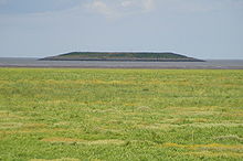
- Outer Trial Bank
-
Outer Trial Bank 
Type Nature reserve Location The Wash, East Anglia, England Coordinates 52°50′30″N 0°14′35″E / 52.8418°N 0.2431°ECoordinates: 52°50′30″N 0°14′35″E / 52.8418°N 0.2431°E Area 4.265 hectares (10.54 acres) The Outer Trial Bank is a circular artificial island in the Wash, East Anglia, England. It is one of two islands constructed during the 1970s for a governmental water resources scheme.[1]
Contents
History
Background
In 1972, the Government undertook a study to assess the feasibility of building a tidal barrage across half of the Wash. The idea was to capture the freshwater from the River Witham, River Welland, River Nene and Great Ouse to build a freshwater reservoir.[1] The study also intended to establish potential improvements to the navigation of sea locks, provide recreational facilities and develop an area of land for a power station.[2]
Construction of the banks
As part of the test, the approval to build an artificial island 2 miles (3.2 km) off the Lincolnshire coast was given in November 1974.[3][4] Building work began in February 1975.[3] The bank (known locally as "the doughnut" due to its biconcave shape[4]) was constructed of a sand fill protected by limestone riprap.[3] Measuring 250 metres (820 ft) in diameter, the island contained a small reservoir measuring 1 hectare (2.5 acres) in the centre.
The other trial bank, built before the Outer Trial Bank, is connected to Norfolk by a causeway on Terrington Marsh.[3]
Conclusions
The study, which was published in 1976 as "The Wash storage scheme",[5] found that the trial alone proved financially unfeasible (costing £3 million),[4] and that the freshwater was too close to the tidal estuary to ensure low salinity and minimal silt levels.[1] The trial was soon abandoned and the plans for the scheme shelved.[4]
Present use
The outer bank is now used as a nesting ground for seabirds within the National Nature Reserve of the Wash. In 2008, an estimated 3,000 pairs of birds nested on the island.[1]
References
- ^ a b c d Richards, Matt (8 October 2008). "Investigation of Wash Island". BBC Look North (BBC). http://news.bbc.co.uk/1/hi/england/7659304.stm. Retrieved 1 March 2010.
- ^ "The Past". The Wash Project. The Wash Estuary Strategy Group. http://www.washestuary.org.uk/details.cfm?id=117. Retrieved 1 March 2010.[dead link]
- ^ a b c d "Wash Water storage scheme". News and Views (British National Committee on Large Dams) (16): 15–16. 1975. http://www.britishdams.org/publications/News%20and%20Views/No16,%201975,%20News%20&%20Views.pdf. Retrieved 2 March 2010.
- ^ a b c d "Abandoned: What's in the Wash?". BBC Lincolnshire. BBC. 15 October 2008. http://www.bbc.co.uk/lincolnshire/content/articles/2008/10/08/abandoned_wash_feature.shtml. Retrieved 1 March 2010.
- ^ "The Wash storage scheme: report on the feasibility study". Central Water Planning Unit. The National Archives. 1976. http://www.nationalarchives.gov.uk/catalogue/displaycataloguedetails.asp?CATID=451605&CATLN=6&Highlight=&FullDetails=True. Retrieved 1 March 2010.
Categories:- Artificial islands
- Geography of Lincolnshire
- Geography of Norfolk
Wikimedia Foundation. 2010.
