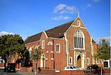
Our Lady of Lourdes, Wanstead

Our Lady of Lourdes, Wanstead
The Parish Church of Our Lady Of Lourdes, Wanstead OLOL2
Location Cambridge Park, Wanstead, London
Country United Kingdom
Denomination Roman Catholic
Website http://www.ourladyoflourdeswanstead.com
History
Dedication Our Lady of Lourdes
Administration
Parish Wanstead
Deanery Redbridge
Diocese Brentwood
Clergy
Priest(s) Rev Patrick J. Salmon, Rev Keiran Dodd (retired)

Our Lady Of Lourdes church is the Catholic parish church of Wanstead, and is part of the Diocese of Brentwood.

History

A mass centre was opened in Wanstead in 1910 by the parish priest of Walthamstow. In 1918 it was transferred to the hall of the newly-opened St. Joseph's convent school, Cambridge Park. Wanstead became a separate parish in 1919, and the church was opened in 1928, and completed in 1934–9.

Architecture

The church was built in the Neo-Gothic style. The church exterior is of red brick with cream stone edgings. Inside, the plan is that of a nave and two aisles on either side. At the back, over the entrance, there is the choir balcony, on which a new organ is being constructed. The interior walls are simply whitewashed, excluding the stonework. Behind the altar is an elaborate stone gothic altarpiece

Exterior seen from Cambridge Park

Recently, two stained glass windows were inserted in the left aisle.

References

Coordinates: 51°34′28″N 0°1′27″E / 51.57444°N 0.02417°E / 51.57444; 0.02417


Wikimedia Foundation. 2010.

Игры ⚽ Поможем решить контрольную работу

Look at other dictionaries:

  • Wanstead — Coordinates: 51°34′40″N 0°01′43″E / 51.577792°N 0.028589°E / 51.577792; 0.028589 …   Wikipedia

  • List of churches in London — St. Paul s from the South London is the location of many famous churches, chapels and cathedrals, in a density unmatched anywhere else in England.[1] …   Wikipedia

  • Brompton Oratory — is also the name of a song on the album The Boatman s Call by Nick Cave and the Bad Seeds. Coordinates: 51°29′50″N 0°10′11″W / 51.49722°N 0.16972° …   Wikipedia

  • St Augustine's, Kilburn — St. Augustine s, Kilburn Photo of St. Augustine s Country United Kingdom Denomination Church of England …   Wikipedia

  • All Souls Church, Langham Place — All Souls Church Country United Kingdom Denomination Church of England …   Wikipedia

  • Chelsea Old Church — Coordinates: 51°28′59″N 0°10′15″W / 51.48306°N 0.17083°W / 51.48306; 0.17083 …   Wikipedia

  • Metropolitan Tabernacle — For the Metropolitan Tabernacle in Mexico City, see Mexico City Metropolitan Cathedral. Coordinates: 51°29′39″N 0°6′4″W / 51.49417°N 0.10111°W …   Wikipedia

  • St Martin-in-the-Fields — For the civil parish abolished in 1922, see St Martin in the Fields (parish). For the chamber orchestra, see Academy of St Martin in the Fields. St Martin in the Fields St Martin in the Fields, London Country United Ki …   Wikipedia

  • St George in the East — For the civil parish abolished in 1927, see St George in the East (parish). St. George in the East St. George in the East seen from the south Country United Kingdom Denomination Church o …   Wikipedia

  • Christ Church, Spitalfields — is an Anglican church built between 1714 and 1729 to a design by Nicholas Hawksmoor. Situated on Commercial Street, in the London Borough of Tower Hamlets, on the eastern border and facing the City of London, it was one of the first (and arguably …   Wikipedia

Share the article and excerpts

Direct link
Do a right-click on the link above
and select “Copy Link”