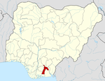
- Osisioma Ngwa
-
Osisioma Ngwa — LGA and town — Coordinates: 5°8′59″N 7°19′49″E / 5.14972°N 7.33028°ECoordinates: 5°8′59″N 7°19′49″E / 5.14972°N 7.33028°E Country  Nigeria
State Abia State Area – Total 76.4 sq mi (198 km2) Population (2006) – Total 219,632 Time zone WAT (UTC+1) Osisioma Ngwa is a Local Government Area of Abia State, Nigeria. Its headquarters are in the town of Osisioma.
It has an area of 198 km² and a population of 219,632 at the 2006 census.
The postal code of the area is 451.[1]
References
- ^ "Post Offices- with map of LGA". NIPOST. http://www.nipost.gov.ng/Postoffice.aspx. Retrieved 2009-10-20.
Capital:UmuahiaLGAs Aba North · Aba South · Arochukwu · Bende · Ikwuano · Isiala Ngwa North · Isiala Ngwa South · Isuikwuato · Obi Ngwa · Ohafia · Osisioma Ngwa · Ugwunagbo · Ukwa East · Ukwa West · Umuahia North · Umuahia South · Umu Nneochi Categories:
- Nigeria geography stubs
- Local Government Areas in Abia State
- Populated places in Abia State
Wikimedia Foundation. 2010.

