- Orangeburg Municipal Airport
-
Orangeburg Municipal Airport 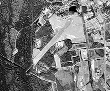
IATA: OGB – ICAO: KOGB Summary Airport type Public Owner Public Operator City of Orangeburg Serves Orangeburg, South Carolina Elevation AMSL 195 ft / 59.4 m Coordinates 33°27′23.65″N 080°51′35.83″W / 33.4565694°N 80.8599528°WCoordinates: 33°27′23.65″N 080°51′35.83″W / 33.4565694°N 80.8599528°W Runways Direction Length Surface ft m 17/35 5,399 1,646 Asphalt 5/23 4,508 1,374 Asphalt Orangeburg Municipal Airport (IATA: OGB, ICAO: KOGB) is a public airport located 2 miles south of Orangeburg, South Carolina. The airport serves the general aviation community, with no scheduled commercial airline service.
Contents
History
Orangeburg airport opened in November, 1937 as a public airport. In 1941 the United States Army Air Forces indicated a need for the airfield as a training airfield and control was turne over to the USAAF in February 1941. An immediate construction program began to turn the civil airport into a military airfield. Construction involved runways and airplane hangars, with three concrete runways, several taxiways and a large parking apron and a control tower. Several large hangars were also constructed. Buildings were ultimately utilitarian and quickly assembled. Most base buildings, not meant for long-term use, were constructed of temporary or semi-permanent materials. Although some hangars had steel frames and the occasional brick or tile brick building could be seen, most support buildings sat on concrete foundations but were of frame construction clad in little more than plywood and tarpaper.
Orangeburg Municipal Airport was activated on 23 August 1941 and was used by the Army Air Forces Flying Training Command, Southeast Training Center (later Eastern Flying Training Command) as a basic flying training airfield, with instruction being carried out by the 58th Flying Training Detachment (Contract Pilot School). The Hawthorne School of Aeronautics was the contractor who operated the primary flight school.
The primary trainer used at Orangeburg by the Hawthorne School of Aeronautics, the Boeing PT-17 Stearman. The president of Hawthorne was Beverly "Bevo" Howard, who had learned to fly at the age of 16. The military designation of the Hawthorne school was the 2162nd Army Air Force Base Unit.
The flight school at Orangeburg Airport operated several auxiliary airfields:
- Jennings Aux Field - Aux No. 1 Orangeburg 33°27′46″N 80°51′23″W / 33.46278°N 80.85639°W
- Hagood Aux Field - Aux No. 2 Orangeburg 33°26′00″N 80°40′30″W / 33.4333333°N 80.675°W
- Kennedy Aux Field - Aux No. 3 Orangeburg 33°23′40″N 81°02′00″W / 33.39444°N 81.0333333°W
-
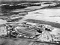
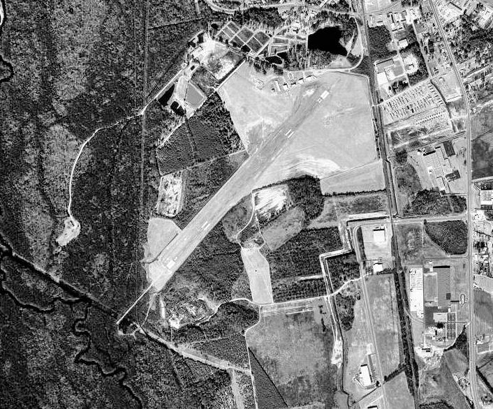
Aerial photo of Orangeburg Airport, South Carolina, 1944
-
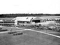
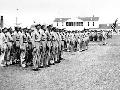
Parade Ground, Barracks and Parking Apron
-
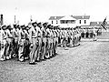
Formation of Free French flying cadets
-

Boeing PT-17 Stearman at Orangeburg
At the end of 1944, training of Free French pilots was transferred from Tuscaloosa, Alabama to Orangeburg. The unit was inactivated on 1 September 1945, and the airport returned to civil control
See also
References
 This article incorporates public domain material from websites or documents of the Air Force Historical Research Agency.
- Shaw, Frederick J. (2004), Locating Air Force Base Sites History’s Legacy, Air Force History and Museums Program, United States Air Force, Washington DC, 2004.
- Manning, Thomas A. (2005), History of Air Education and Training Command, 1942–2002. Office of History and Research, Headquarters, AETC, Randolph AFB, Texas ASIN: B000NYX3PC
External links
- Resources for this airport:
- AirNav airport information for KOGB
- ASN accident history for OGB
- FlightAware airport information and live flight tracker
- NOAA/NWS latest weather observations
- SkyVector aeronautical chart for KOGB
- FAA current OGB delay information
 Army Air Forces Training Command
Flying Training Flying Schools Eastern Flying Training Command · Central Flying Training Command · Western Flying Training CommandSpecialized Schools Bombardier · Contract Flying · Glider Training · Gunnery · Navigator
Technical Training Eastern Technical Training Command · Central Technical Training Command · Western Technical Training CommandCategories:- 1937 establishments
- Airfields of the United States Army Air Forces in South Carolina
- USAAF Contract Flying School Airfields
- Airports in South Carolina
- Transportation in Orangeburg County, South Carolina
- Buildings and structures in Orangeburg County, South Carolina


Wikimedia Foundation. 2010.