Oosteinde, Groningen

Oosteinde, Groningen
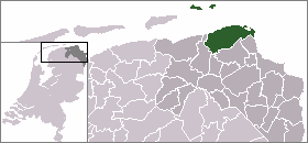
Oosteinde
—  Dorp  —
Coordinates: 53°24′49″N 6°47′37″E / 53.41361°N 6.79361°E / 53.41361; 6.79361Coordinates: 53°24′49″N 6°47′37″E / 53.41361°N 6.79361°E / 53.41361; 6.79361
Country Netherlands
Province Groningen (province)
Municipality Eemsmond
Population (2008) 150
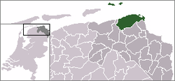
Municipality of Eemsmond

Oosteinde is a village in the municipality of Eemsmond, Groningen, the Netherlands. It is located southeast of Roodeschool, near the river Groote Tjariet.


Wikimedia Foundation. 2010.

Игры ⚽ Поможем написать реферат

Look at other dictionaries:

  • Uithuizen — Gemeinde Eemsmond Flagge Wappen Provinz Groningen …   Deutsch Wikipedia

  • Warffum — Gemeinde Eemsmond Flagge Wappen Provinz Groningen …   Deutsch Wikipedia

  • De Wolden — Gemeinde De Wolden Flagge Wappen Provinz …   Deutsch Wikipedia

  • Eemsmond — Gemeinde Eemsmond Flagge Wappen der Gemeinde Eemsmond Wappen Provinz Groningen Bürgermeister Marijke van Beek Sitz der Gemeinde Uithuizen …   Deutsch Wikipedia

  • Oudeschip — 53.4305555555566.8227777777778 Koordinaten: 53° 26′ N, 6° 49′ O …   Deutsch Wikipedia

  • Eemsmond — Infobox Settlement official name = Eemsmond mapsize = 280px subdivision type = Country subdivision name = Netherlands subdivision type1 = Province subdivision name1 = Groningen area footnotes = (2006) area total km2 = 543.36 area land km2 =… …   Wikipedia

  • Grietenij — A grietenij was a forerunner to the gemeente or municipality in Frisia, particularly in Friesland, and also in Groningen which are now a part of the Netherlands. From the end of the 16th century until 1851, there were a total of 30 Grietenijen in …   Wikipedia

Share the article and excerpts

Direct link
Do a right-click on the link above
and select “Copy Link”