- Olimje
-
Olimje Olimje Castle Location in Slovenia Coordinates: 46°9′13.6″N 15°34′8.89″E / 46.153778°N 15.5691361°ECoordinates: 46°9′13.6″N 15°34′8.89″E / 46.153778°N 15.5691361°E Country  Slovenia
Traditional region Styria Statistical region Savinja Municipality Podčetrtek Area – Total 9.5 km2 (3.7 sq mi) Elevation 413.5 m (1,357 ft) Population (2002) – Total 250 [1] Olimje is a settlement in the Municipality of Podčetrtek in eastern Slovenia. The area around Podčetrtek was traditionally part of the region of Lower Styria. It is now included in the Savinja statistical region.[2]
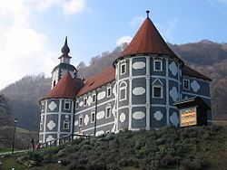
Olimje Castle is a 16th-century castle located in the settlement. In the 17th century, when it was converted to a monastery, the monastic church dedicated to the Assumption of Mary was built. It is now also the local parish church.[3] A second church in the settlement is dedicated to Saint Andrew and is a Late Gothic single nave building dating to the 15th century.[4]
References
- ^ Statistical Office of the Republic of Slovenia
- ^ Podčetrtek municipal site
- ^ Slovenian Ministry of Culture register of national heritage reference numbers 496 & 3211
- ^ Slovenian Ministry of Culture register of national heritage reference number 3213
External links
Podčetrtek Settlements Administrative centre: Podčetrtek
Brezovec pri Polju, Cmereška Gorca, Golobinjek ob Sotli, Gostinca, Imeno, Imenska Gorca, Jerčin, Lastnič, Nezbiše, Olimje, Pecelj, Polje ob Sotli, Prelasko, Pristava pri Lesičnem, Pristava pri Mestinju, Roginska Gorca, Rudnica, Sedlarjevo, Sela, Sodna Vas, Sveta Ema, Verače, Vidovica, Virštanj, VonarjeLandmarks Categories:- Populated places in the Municipality of Podčetrtek
- Savinjska statistical region geography stubs
Wikimedia Foundation. 2010.


