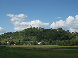
- Cmereška Gorca
-
Cmereška Gorca Location in Slovenia Coordinates: 46°11′6.28″N 15°35′21.87″E / 46.1850778°N 15.5894083°ECoordinates: 46°11′6.28″N 15°35′21.87″E / 46.1850778°N 15.5894083°E Country  Slovenia
Traditional region Styria Statistical region Savinja Municipality Podčetrtek Area – Total 1.42 km2 (0.5 sq mi) Elevation 299 m (981 ft) Population (2002) – Total 83 [1] Cmereška Gorca is a settlement in the Municipality of Podčetrtek in eastern Slovenia. The area around Podčetrtek was traditionally part of the region of Lower Styria. It is now included in the Savinja statistical region.[2]
The settlement is built around a small hill with a local church dedicated to Saint Urban. It belongs to the Parish of Sveta Ema. Its belfry dates to the 17th century, but the remainder of the church was rebuilt in 1850.[3]
References
External links
Podčetrtek Settlements Administrative centre: Podčetrtek
Brezovec pri Polju, Cmereška Gorca, Golobinjek ob Sotli, Gostinca, Imeno, Imenska Gorca, Jerčin, Lastnič, Nezbiše, Olimje, Pecelj, Polje ob Sotli, Prelasko, Pristava pri Lesičnem, Pristava pri Mestinju, Roginska Gorca, Rudnica, Sedlarjevo, Sela, Sodna Vas, Sveta Ema, Verače, Vidovica, Virštanj, VonarjeLandmarks Categories:- Populated places in the Municipality of Podčetrtek
- Savinjska statistical region geography stubs
Wikimedia Foundation. 2010.


