- Old Kilcullen
-
This article is about the original (walled) town. For the modern town, formally "Kilcullen Bridge", see Kilcullen.
Old Kilcullen
Sean Chill Chuilinn— Town — Location in Ireland
 Old Kilcullen
Coordinates: 53°06′25″N 6°45′45″W / 53.106967°N 6.762521°WCoordinates: 53°06′25″N 6°45′45″W / 53.106967°N 6.762521°W Country Ireland Province Leinster County County Kildare Time zone WET (UTC+0) - Summer (DST) IST (WEST) (UTC-1) Irish Grid Reference N830071 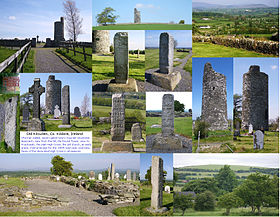 Images of Old Kilcullen in postcard form, including the Round Tower and the "plain" and decorated High Crosses
Old Kilcullen, formerly Kilcullen (Cill Chuilinn, "the Church of the Holly" in Irish), is a townland in County Kildare, Ireland, which includes a noted religious archaeological site within its boundary. It was formerly the site of a walled town, and before that of an ecclesiastical settlement dating from the 5th century. The original settlement gave its name to the substantial surrounding Civil Parish and barony.
The urban centre of the area moved about 2 km west and slightly north to Kilcullen Bridge on the River Liffey, often now simply known as Kilcullen, over the centuries following the construction of a bridge there in 1319. Old Kilcullen is also under 5 km from Newbridge and around 13 km from Naas.
Old Kilcullen is the site of a round tower and a decorated High Cross, and another, much older, historic site, Dun Ailinne, is on the next hill to the west, Knockaulin.
Contents
Location and access
The religious archaeological site of Old Kilcullen is situated on a hill around 2 kilometres from Kilcullen Bridge[1]. It can be reached from a number of minor roads to the east off the Kilcullen-Athy road, or from an exit in the northbound carriageway of the Dublin-Waterford road. There is just one official path to the site, and a small car park at its entrance.
At ground level today, the site appears to be confined to a churchyard with surviving stone features at the top of a gently sloping hill, but aerial and ground surveys have shown a far greater extent to the former settlement, including embankments on the slopes of the hill.
The site has no immediate public transport access but Kilcullen Bridge is served by two long-distance bus services, operated by Bus Éireann Teo. and JJ Kavanagh Ltd. Old Kilcullen is under 5 km from Newbridge and around 13 km from Naas.
History
Kilcullen begun as a monastic settlement, in the period around 448, assigned clergy by St. Patrick. The choice of location for the settlement was perhaps related to the nearby Dun Ailinne, a ceremonial and possible palace site related to the kings of Leinster, though Dun Ailinne long predates any known settlement at Old Kilcullen.
The settlement was assigned a bishop, (St.) Iserninus or Isernine, together with (St.) (Eoghan) MacTail or Mactalius, who later took sole responsibility.[2] Whether these two were contemporaries is uncertain, as MacTail's date of death is usually given as June 11 548[3], and on the other hand, one source mentions only Mac Tail as founding bishop[4] and one gives his death as occurring in 549[5]
Old Kilcullen was raided by Vikings, landing at the location of the modern town, at least twice, in 936[6] and 944[7]. In the former raid, it is reported that a thousand prisoners were taken, which suggests that the then population was very substantial. Other mentions in the Annals include reference to the deaths of key church figures, including Bishops and Abbots (sometimes the one person).[8][9][10][11]
The town reached its peak in early Anglo-Norman times, as a walled town with seven gates and seven, or perhaps eight, roads, and regular markets. There was also some form of castle, which was by the time of Henry VIII held by the (Fitz-)Eustace family, who held for a time the title Baron of Kilcullen.
Kilcullen Bridge
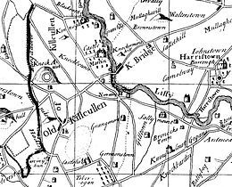
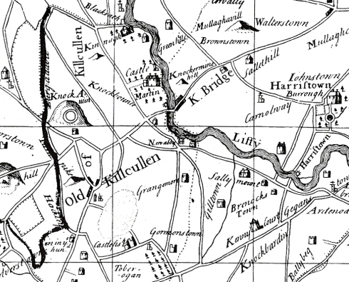
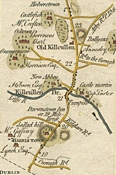
 The two Kilcullens on an early Irish roadmap
The new town officially known and mapped as Kilcullen Bridge began to develop after 1319 when a bridge across the River Liffey was constructed at that place by a canon, Maurice Jakis (or Jacquis or Jakes), of Kildare Cathedral. It took over, over succeeding centuries, from the old centre, though until the late 19th century, Old Kilcullen townland had a greater population than Kilcullen Bridge. Originally, as shown on maps even as late as the late 18th century, the new settlement was wholly on the eastern bank of the Liffey.
Later years
1641 disturbances
The fortification here was initially held by the parliamentary forces in 1641, but later taken by the Royalist army, and then recaptured and burned by the parliamentarians in 1647.
1798 rebellion
In 1798, this was the site of the Battle of Kilcullen, the first phase of which was won by the rebels, before they were driven out, and back to Knockaulin (Dun Ailinne) by General Dundas. During the battle, the round tower was damaged[1], with, for example, the four windows mentioned in an account of 1782 being reduced to one.[12] It was subsequently stabilised in its current form.
19th century
At some point, the settlement, now just a small village, lost the market, whose licence was by then in clerical hands, to Kilcullen Bridge, retaining a small twice-yearly fair. It retained a small church, by then Church of Ireland, until some time in the 19th century (after 1836), and revenue from this went to support two canons of Christchurch Cathedral, Dublin.
Activity was also lost as the main road from Dublin to Carlow (via Athy) diverted away from the hill.
The round tower was taken under State care in the late 19th century.
Gordon Bennett Road Race of 1903
One of the earliest international motor races, the Gordon Bennett Road Race, had its third running in Ireland, in 1903, and started in the district of Old Kilcullen, with the Grand Stand at Ballyshannon Crossroads. It was won by a German, followed by a Frenchman.[13][14]
Current situation
Little now remains visible of the original town site beyond the low-walled churchyard, which contains the damaged round tower, the remnants of a church, two Irish High Crosses, the base of another large cross, and many graves. However, further traces of structures can be seen in aerial photography.
In addition to the historic area, the townland of Old Kilcullen includes homes, farms, a public house, and a Kildare County Council reservoir.
Round Tower
The round tower is now a little over 10m high at the lowest point of its uneven top remaining course, stabilised after damage during the Battle of Kilcullen. One window, of at least four large windows seen in earlier illustrations and mentioned in descriptions, remains.[12] The round-headed doorway, which is about 1.7m high at maximum, is about 2m above ground level.[12] Beside the door is a plaque declaring the tower's protected status.
High Crosses
There are two distinct Irish High Crosses, and what may be the base of a third, at different locations within the churchyard.
The "decorated high cross" has four illustrated faces, with a range of panels. It did not survive intact - it is known that it was leaning by 1862, and later lay on the ground for some years, and when it was remounted in the late 19th century, parts of at least one panel were lost, and parts of the panel which had been facing upwards had been badly eroded.
The "plain high cross" may have had the beginnings of decoration, but has no finished ornamentation.
Church
The remains of the church now extend only slightly above ground level.
Structures formerly present
Until at least the late 18th century, one of the reputed "seven gates" remained.
External sources
- Kilcullen(-Bridge), Co. Kildare, Ireland: The Bridge (monthly publication, 1970s to today), various issues, various committee members / editors
- Grose, Francis: Antiquities of Ireland, Vol. 2 (of 2), preface illustration and pp. 27–28 with second illustration (illustratiobns by Lieut. Daniel Grose)
References and notes
- ^ a b Kildare eHistory posting
- ^ The Catholic Encyclopedia, "Diocese of Kildare and Leighlin", History section
- ^ O'Cleirigh et al. (compilers and authors, at Donegal), O'Donovan (editor and translator, at Dublin), The Annals of the Four Masters, item 548.4, p.187: "St. Mac Tail of Cill Cuilinn (i.e. Eoghan, son of Corcran), died on the eleventh day of the month of June."
- ^ Lives of the Saints from the Book of Lismore (authors unknown, 1200-1300), List of Witnesses, BE(THA) Patraic inso, & tabrad g(ach a)on legfas bennacht for a(n)mannaibh na lanamhna dar' sc(ríbad in lebhar so) - lines 419-421, "Fothaighis Pátraic iarum cealla & congbala imdha i Laignib, ocus for-facuib bennachtain forru & for h-Uibh Cennselaig sainriudh, & for-facuibh h-Uasailli i Cill h- Uasailli & Mac Tail i Cill Cuilinn..."
- ^ Unknown author, The Annals of Ulster, entry U549.3, "A great mortality in which these rested: Finnia moccu Telduib, Colam, descendant of Crimthann, Mac Táil of Cell Cuilinn, ..." (Retrieved from [1] on 24 August 2009.)
- ^ O'Cleirigh et al., O'Donovan, ibid, item 936.14: "Amhlaibh, son of Godfrey, came to Dublin again, and plundered Cill-Cuilinn, and carried off ten hundred prisoners from thence."
- ^ O'Cleirigh et al., O'Donovan, ibid, p. 657, item 944.7: "The plundering of Cill-Cuilinn by the foreigners, i.e. by Amhlaeibh Cuaran and his followers."
- ^ O'Cleirigh et al., O'Donovan, ibid, item 898.5, p.556: "Ailill, son of Aongus, abbot of Cill-Cuilinn." (Retrieved from [2] on 24 August 2009.)
- ^ O'Cleirigh et al., O'Donovan, ibid, p.633, item 935.3: "Diarmaid, son of Ailell, Abbot of Cill-Cuilinn, died at an advanced age."
- ^ O'Cleirigh et al., O'Donovan, ibid, p.662, item 948.4: "...Cormac Ua h-Ailella, airchinneach of Cill-Cuilinn..."
- ^ O'Cleirigh et al., O'Donovan, ibid, p.686, item 962.2: "...Suibhne, son of Segonan, Bishop and ruler of Cill-Cuilinn, died."
- ^ a b c Kilcullen Round Tower at the official website of the Kildare Local Authorities
- ^ Kildare(?), Ireland: The Leinster Leader, Saturday 4th July 1903 (final edition), p.5
- ^ Kildare(?), Ireland: The Leinster Leader, Saturday 4th July 1903 (final edition), p.4 - Editorial comment
Categories:- Kilcullen
- National Monuments in County Kildare


Wikimedia Foundation. 2010.