- Oji River
-
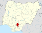
Oji River — LGA and towns — Location in Nigeria Coordinates: 6°16′N 7°16′E / 6.267°N 7.267°ECoordinates: 6°16′N 7°16′E / 6.267°N 7.267°E Country  Nigeria
State Enugu State Area - Total 403 km2 (155.6 sq mi) Population (2006 census) - Total 126,587 Time zone WAT (UTC+1) 3-digit postal code prefix 401 ISO 3166 code NG.EN.OR Oji River is a Local Government Area of Enugu State, Nigeria to the south bordering Anambra State and Abia State. Its headquarters are in the town of Oji River.
It has an area of 403 km² and a population of 126,587 at the 2006 census.
The postal code of the area is 401.[1]
References
- ^ "Post Offices- with map of LGA". NIPOST. http://www.nipost.gov.ng/PostCode.aspx. Retrieved 2009-10-20.
 Enugu State
State capital: Enugu LGAs Aninri · Awgu · Enugu East · Enugu North · Enugu South · Ezeagu · Igbo Etiti · Igbo Eze North · Igbo Eze South · Isi Uzo · Nkanu East · Nkanu West · Nsukka · Oji River · Udenu · Udi · Uzo Uwani
 Categories:
- Local Government Areas in Enugu State
- Populated places in Enugu State
- Nigeria geography stubs
Wikimedia Foundation. 2010.

