- 1996 Oakfield tornado
-
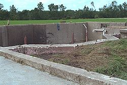 Remains of a home after been swept by an F5 tornado near Oakfield (Courtesy of NWS Milwaukee, Wisconsin)
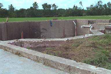
The 1996 Oakfield Tornado is the name of an F5 tornado which destroyed Oakfield, Wisconsin on July 18, 1996.[1] In addition, strong thunderstorms brought heavy rains, lightning, and gusty winds to that region of Fond du Lac County. All of these elements resulted from the passage of a cold front. The violent tornado developed outside of town and moved southeastward across Wisconsin taking direct aim at Oakfield. At 7:15 p.m. the large tornado struck the 1,012 person town, injuring 17 people but killing none. Damage estimates totaled over $40 million as 47 of 327 homes were destroyed. Also 56 homes as well as numerous businesses and churches suffered heavy damage. A state of emergency was declared by Wisconsin Governor Tommy Thompson allowing National Guard soldiers to be called in to aid victims and clear debris.
The tornado was strong enough to level the Friday Canning Company, while throwing up millions of empty cans and leaving them sprawled over a 50 mile (80 km) radius. Besides structural damage to buildings the tornado was very costly to farmers; Crops, livestock, and farm equipment were also gone. The original National Weather Service report from Milwaukee/Sullivan categorized the tornado to be an F3 to F4 tornado on the Fujita scale. It was later upgraded to an F5, the most severe tornado possible. It would be the only F5 tornado to hit the United States that year. The tornado width when it reached its maximum strength was about 100 yards (92m) wide, making it one of the narrowest F5's on record. The tornado was documented by at least three experienced storm chasers.
There were eleven other tornadoes in Wisconsin from this storm complex, with one death at Marytown, Wisconsin.[2]
Contents
Tornado table
Confirmed
TotalConfirmed
F0Confirmed
F1Confirmed
F2Confirmed
F3Confirmed
F4Confirmed
F512 5 5 1 0 0 1 F# Location County Time (UTC) Path length Damage Wisconsin F1 SW of Tomahawk Lincoln 2220 3 miles
(4.8 km)Three cottages, one home and a tavern were damaged. A garage was removed from its foundation and two boats were flipped. F1 SW of Berlin Green Lake 2315 2 miles
(3.2 km)Damage limited to trees F2 SE of Brothertown Calumet, Wisconsin 0005 6.4 miles
(10.2 km)1 death North of Marytown, a couple of dozens of barns, sheds and homes were damaged or destroyed. In Marytown, a house trailer, three homes and a machine shed were destroyed. In Calumet County, two barns, trees, crops were damaged and calf houses were thrown 1,000 feet (300 m) F5 Oakfield area (1st tornado) Fond du Lac 0005 13.3 miles
(21.3 km)4 homes were swept from their foundation and automobiles were thrown 400 feet (120 m) away. 60 homes, 6 businesses, a canning company, two churches, 18 barns, several vehicles and several sheds were destroyed. 150 homes and businesses were also damaged. 500 acres (2.0 km2) of crops were also wiped away and total damage amounts was near $40 million. 12 to 17 people were injured. A second tornado also hit the area taking a similar path. F0 NW of Marytown Fond du Lac 0007 1.2 miles
(1.9 km)Damage to farm crops F0 S of Charlesburg Calumet 0010 0.1 miles
(0.16 km)Two wheat fields were flattened F0 Oakfield area (2nd tornado) Fond du Lac 0025 0.6 miles
(1 km)Second tornado moved through portions of the damage path of the initial tornado, picking up debris from the ground but did not cause any additional structural damage F0 NW of Fond du Lac Fond du Lac 0027 0.2 miles
(0.32 km)A barn, machinery and crops were damaged or destroyed F0 E of Brownsville Fond du Lac 0055 0.1 miles
(0.16 km)Portions of a corn field were flattened F1 SW of Beechwood Sheboygan 0110 0.9 miles
(1.4 km)Several homes and a few barns were damaged along with crops F1 E of Fredonia Ozaukee 0118 7.6 miles
(12.2 km)4 barns, 3 machine sheds and a 1-car garage were destroyed while 6 homes, 1 barn, 3 machine sheds and 1 garage were damaged. Several vehicles were also damaged or destroyed as well as 500 acres (2.0 km2) of crops. F0 E of Knellsville Ozaukee 0128 0.8 miles
(1.3 km)Brief tornado with little or no damage Sources: Tornado History Project Storm Data - July 18, 1996 See also
References
- ^ Tornado: Oakfield, Wisconsin
- ^ Wisconsin Tornado Outbreak of July 18, 1996: Formation of Tornadic Supercells, WARNING: PDF file, Renee Geiser, Retrieved October 9, 2007
External links
Categories:- F5 tornadoes
- Tornadoes of 1996
- Tornadoes in Wisconsin
- Fond du Lac County, Wisconsin
- 1996 in the United States
Wikimedia Foundation. 2010.