- Norton Water Tower
-
Coordinates: 53°19′46″N 2°40′17″W / 53.3295°N 2.6714°W
Norton Water Tower 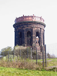 Norton Water Tower
Location: Norton, Runcorn, Cheshire, England OS grid reference: SJ 553 816 Built: 1892 Listed Building – Grade II Designated: 31 October 1983 Reference #: 1335884 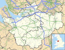
 Location in Cheshire
Norton Water Tower is a water tower in Norton, Runcorn, Cheshire, England. It has been designated by English Heritage as a Grade II listed building.[1]
Contents
History
It was built between 1888 and 1892 on the water pipeline between Lake Vyrnwy in North Wales and Liverpool to act as a balancing reservoir in the process of supplying water to Runcorn and Liverpool. Water is carried to Liverpool through a tunnel 10 feet (3 m) wide under the River Mersey.[2] The tower was designed by George F. Deacon, the Chief Engineer of the Liverpool Corporation Waterworks Department.[3]
Description
It is built in red sandstone in the shape of a cylinder 99 feet (30 m) high with a diameter of 82 feet (25 m). On its top is a cast iron tank with a capacity of 650,000 gallons.[3] Ten pilasters rise from a rock-faced base and between them are round-headed arches. Above these is a frieze with a Latin inscription and over this is a cornice. On the top is the iron tank with a decorated exterior.[1] Translated, the inscription on the frieze reads:
This water, derived from the sources of the Severn, is brought to the City of Liverpool, a distance of eighty miles, through the mountains and over the plains of Wales and the intervening country, at the cost of the municipality, in the year of Our Lord 1892.[2]
See also
- Listed buildings in Runcorn (urban area)
References
- ^ a b "Norton Water Tower, Runcorn", The National Heritage List for England (English Heritage), 2011, http://list.english-heritage.org.uk/resultsingle.aspx?uid=1335884, retrieved 23 April 2011
- ^ a b Starkey, H. F. (1990), Old Runcorn, Halton Borough Council, p. 162
- ^ a b Ritchie, J. O. C. (1957), "Water Towers", The Structural Engineer: 2, http://google.com/search?q=cache:isg2ZNjymakJ:https://www.istructe.org/thestructuralengineer/HC/getfile.asp%3Fid%3D2332+%22norton+water+tower%22&hl=en&ct=clnk&cd=26&gl=uk, retrieved 2009-01-01
Categories:- Grade II listed buildings in Cheshire
- Water towers
- Runcorn
- Buildings and structures completed in 1892


Wikimedia Foundation. 2010.