Northeast 82nd Avenue (MAX station)
- Northeast 82nd Avenue (MAX station)
-
Northeast 82nd Avenue
MAX light rail station |

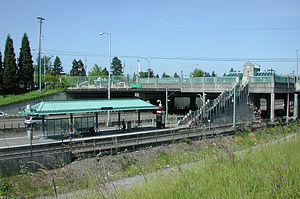
Steps connect the station to the street above. |
| Station statistics |
| Address |
Northeast Eighty-second Avenue & Halsey Street |
| Lines |
MAX Light Rail
|
| Platforms |
Island platform |
| Tracks |
2 |
| Other information |
| Opened |
September 5, 1986 |
| Accessible |
 |
| Owned by |
TriMet |
| Fare zone |
2 |
| Services |
| Preceding station |
|
MAX Light Rail |
|
Following station |
|
toward Hatfield Government Center
|
|
Blue Line |
|
Gateway/Northeast 99th Avenue Transit Center
|
|
toward PSU Urban Center/Southwest 5th & Mill Street
|
|
Green Line |
|
Gateway/Northeast 99th Avenue Transit Center
toward Clackamas Town Center Transit Center
|
|
toward Beaverton Transit Center
|
|
Red Line |
|
Gateway/Northeast 99th Avenue Transit Center
toward Portland International Airport
|
|
The Northeast 82nd Avenue station is a light rail station on the MAX Blue, Green and Red lines in Portland, Oregon. It is the 14th stop eastbound on the Eastside MAX.
The station is at the intersection of Northeast 82nd Avenue Interstate 84. This station is connected to Northeast 82nd Avenue by a stairway and one elevator. Access to the station is from the East side of the 82nd Avenue overpass.
Bus line connections
This station is served by the following bus lines:
- 72 - Killingsworth/82nd Ave
- 77 - Broadway/Halsey
External links
Coordinates: 45°32′00″N 122°34′42″W / 45.533388°N 122.57824°W / 45.533388; -122.57824
Wikimedia Foundation.
2010.
Look at other dictionaries:
Northeast 60th Avenue (MAX station) — Northeast 60th Avenue MAX light rail station An eastbound train arrives at the station. The view is from the Northeast 60th Avenue overpass above Interstate 84 … Wikipedia
Northeast 82nd Avenue — Infobox Station name=Northeast 82nd Avenue image size= image caption= address=NE 82nd Halsey line=MAX Light Railrail color box|system=TMTC|line=Bluerail color box|system=TMTC|line=Red other= platform=Island platform tracks=2 parking=Nearest Park… … Wikipedia
Oregon Route 213 — For the unsigned Highway 215, see Clear Lake Belknap Springs Highway. For the former unsigned Highway 213, see Lyons Mill City Highway. Oregon Route 213 … Wikipedia
Comfort Inn Portland — (Портленд,США) Категория отеля: 3 звездочный отель Адрес: 8225 Northeast Wasco … Каталог отелей
Edmonton — This article is about the capital of Alberta. For other uses, see Edmonton (disambiguation). Edmonton City City of Edmonton … Wikipedia
Portland, Oregon — Portland City City of Portland Portland s skyline from the west, with Mount Hood on the left … Wikipedia
Old Town Chinatown, Portland, Oregon — Neighborhood representation Association … Wikipedia
NEW YORK CITY — NEW YORK CITY, foremost city of the Western Hemisphere and largest urban Jewish community in history; pop. 7,771,730 (1970), est. Jewish pop. 1,836,000 (1968); metropolitan area 11,448,480 (1970), metropolitan area Jewish (1968), 2,381,000… … Encyclopedia of Judaism
KFYO (AM) — Infobox Radio station name = KFYO airdate = 1926 in Texarkana, TX, September 25, 1927 in Breckenridge, TX frequency = 790 (kHz) area = Lubbock, Texas format = News/Talk owner = Gap Broadcasting licensee = Gap Broadcasting Lubbock License, LLC… … Wikipedia
Madison South, Portland, Oregon — Infobox Neighborhood Portland OR neighborhood name = Madison South association name = Madison South Neighborhood Association association website = coalition name = Central Northeast Neighbors, Inc. coalition website = http://www.cnncoalition.org/ … Wikipedia


