North–South Trail

North–South Trail
Ninigret Beach at southern end of the North-South Trail

The North–South Trail is a 77-mile (124 km) hiking trail that runs the length of Rhode Island from the Atlantic Ocean in Charlestown to the Massachusetts border in Burrillville, Rhode Island. The trail is remarkably rural and scenic. Features include attractive lakeshores, bogs, beaches, hills, rock outcrops, farmland, and dense woodland.

The North–South Trail is the logical extension of the Midstate Trail in Massachusetts and the Wapack Trail in New Hampshire; these three trails together make up a 191-mile (307 km) greenway footpath.

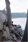
Bowdish Reservoir along the North–South Trail

References


Wikimedia Foundation. 2010.

Игры ⚽ Нужна курсовая?

Look at other dictionaries:

  • North-South Trail — The North South Trail is a 77 mile hiking trail that runs the length of Rhode Island from the Atlantic Ocean in Charlestown to the Massachusetts border in Burrillville, Rhode Island. The trail is remarkably rural and scenic. Features include… …   Wikipedia

  • North Kaibab Trail — This article is about the hiking trail at the north rim of Grand Canyon. For the trail from the south rim, see South Kaibab Trail. North Kaibab Trail Ribbon Falls on the North Kaibab Trail Length 14 mi; 22.5 km Location …   Wikipedia

  • North Bass Trail — This article is about the hiking trail at the north rim of Grand Canyon. For the trail from the south rim, see South Bass Trail. North Bass Trail The Colorado River viewed from the near terminus of the North Bass Trail. Length …   Wikipedia

  • North Road Trail — The North Road Trail is a shared use bicycle and pedestrian path running up the centre of the divided North Road in Clayton, Melbourne. It connects with the Station Trail at Huntingdale Station. At Clayton Road, it moves to the north side of the… …   Wikipedia

  • North Mowich Trail Shelter — U.S. National Register of Historic Places …   Wikipedia

  • North–South Lake — North South Lake View from North Point Location Greene County, New York Coordinates …   Wikipedia

  • North–South Rail Link — The North–South Rail Link is a proposed pair of approximately 1.5 mile (2.4 km) long rail tunnels below downtown Boston, Massachusetts.[1] The tunnels would serve the goals of better unification for Boston s separate northern and southern… …   Wikipedia

  • North–South Expressway, Malaysia — For North–South Expressway in Singapore, see North–South Expressway, Singapore. North–South Expressway Route information …   Wikipedia

  • North-South Lake — Infobox lake lake name = North South Lake image lake = North and South Lakes.jpg caption lake = View from North Point image bathymetry = caption bathymetry = location = Greene County, New York coords =… …   Wikipedia

  • List of north–south roads in Toronto — The following is a list of the north–south arterial thoroughfares in the Canadian city of Toronto. The city is organized in a grid pattern dating back to the plan laid out by Augustus Jones between 1793 and 1797. Most streets are aligned in the… …   Wikipedia

Share the article and excerpts

Direct link
Do a right-click on the link above
and select “Copy Link”