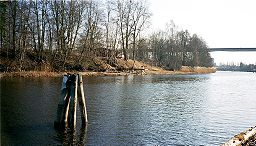
Norsälven

Norsälven
Norsälven
River
Norsälven at Älvenäs
Country Sweden
County Värmland
Tributaries
 - left Rottnan, Röjdan
 - right Ljusnan River
Source Fryken
 - elevation 62 m (203 ft)
Mouth Vänern
 - elevation 44 m (144 ft)
 - coordinates 59°21′50″N 13°11′10″E / 59.36389°N 13.18611°E / 59.36389; 13.18611
Length 180 km (112 mi) [1]
Basin 4,160 km2 (1,606 sq mi) [1]
Discharge
 - average 56 m3/s (1,978 cu ft/s) [1]
 - max 192 m3/s (6,780 cu ft/s)

Norsälven is a river flowing between Fryken and Vänern in Värmland, Sweden. It used to bee an important river for log driving. During the 1950s, there were 6.23 million logs annually floating in the river. The length is 28 km (including Ljusnan River (Värmland) 179 km).

References

  1. ^ a b c "Norsälven" (in Swedish). Nationalencyklopedin. http://www.ne.se/norsälven. Retrieved 3 August 2010.  (subscription required)

Wikimedia Foundation. 2010.

Игры ⚽ Поможем написать курсовую

Look at other dictionaries:

  • Fryken — Bild gesucht  BW Geographische Lage Värmland, Schweden Abfluss …   Deutsch Wikipedia

  • Värmlandsbahn — Legende Västra stambanan nach Göteborg …   Deutsch Wikipedia

  • Värmlandsbanan — Laxå–Eda Bahnhof Högboda Kursbuchstrecke: 70 Streckennummer: 12 Streckenlänge: 208 km Spurweite …   Deutsch Wikipedia

  • Lago Vänern — Vista de satélite Localización geográfica / administrativa Continente (sub) Europa …   Wikipedia Español

  • Vänernbanan — Göteborg–Kil Kursbuchstrecke: 71 Streckennummer: 11 Streckenlänge: 232 km Spurweite: 1435 mm (Normalspur) Stromsystem: 15 kV 16 2/3 Hz  Höchstgeschwindigkeit: Göteborg–Skäle …   Deutsch Wikipedia

  • Bergslagsbanan — Göteborg–Falun Göteborg BJ Streckenlänge: 458 km Spurweite: 1435 mm (Normalspur) Legende …   Deutsch Wikipedia

Share the article and excerpts

Direct link
Do a right-click on the link above
and select “Copy Link”