- Nordvik (port)
-
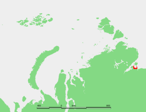 Map showing the location of Nordvik Bay. Nordvik penal colony was located in the small peninsula on the western side of the bay.
Nordvik (Russian: Нордвик) was a harbor-port in the Khatanga Gulf (Laptev Sea) at the mouth of the Khatanga River. It was located on the Uryung Tumus Peninsula, west of a bay called Nordvik Bay (Бухта Нордвик; Bukhta Nordvik). Formerly there was a small town and a penal colony next to the harbour, called Nordvik. The climate is exceptionally severe, with prolonged, bitter winters.
Near Nordvik there is a paleozoic salt dome known as Tus-Takh on the Uryung Tumus Peninsula itself. It was suspected that the ground underneath would probably yield oil and gas. The remains of a plesiosaur (Plesiosaurus robustus) were also found on this peninsula.
History
In 1933 the newly-formed Glavsevmorput (Chief Directorate of the Northern Sea Route) sent the freighter Pravda to Nordvik with an oil exploration expedition led by N.N. Urvantsev. By September 4 Pravda was close to Nordvik. Kapitan Belitskiy had decided to approach Nordvik Bay from the east, between Poluostrov Paksa and Bolshoy Begichev Island. Despite having no knowledge of the depth of the channel, Belitskiy went ahead without taking the elementary precaution of sounding, and Pravda twice ran aground in the center of the channel.
According to Urvantsev, drilling at Nordvik over the next few seasons revealed small, shallow oil pockets in connection with salt structures with little commercial significance. However the salt itself was extracted on a fairly massive scale by means of forced labourers in a penal colony. From the 1930s onwards Nordvik became an important source of salt supply for the northern fisheries. Although the original prospects for oil at Nordvik did not materialize, experience was gained in the exploration for hydrocarbons within the continuous permafrost zones. This experience proved invaluable in the later exploration and exploitation of the massive oil and gas fields of Western Siberia.
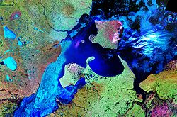 The bay of Nordvik (center) between the rivershed areas of the Khatanga (left: Khatanga Gulf) and Anabar (right: Anabar Gulf). Bolshoy Begichev Island is located to the north.
The penal colony closed in mid 1940's when Americans arrived in Nordvik as allies of the USSR. The salt was extracted by internal deportees rather than prisoners after the camp closure. The settlement at Nordvik was closed in 1956.
References
- William Barr, The First Soviet Convoy to the Mouth of the Lena.
- Memorial (in Russian)
- Stalin's camps (in Russian)
- Newspaper article about expedition (in Russian)
- Map marking plesiosaur finds
- Nordvik entry from Dead Cities (in Russian)
Categories:


Wikimedia Foundation. 2010.