Nimrod Islands

Nimrod Islands

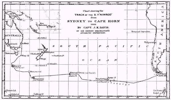
The Nimrod Islands were a group of islands first reported in 1828 by Captain Eilbeck of the ship Nimrod while sailing from Port Jackson around Cape Horn. Their reported location was east of Emerald Island and west of Dougherty Island, at approximately 56°S 158°W / 56°S 158°W / -56; -158.[1]

The explorer John Biscoe in the brig Tula searched for the Nimrod Group without success in 1831 during the Southern Ocean Expedition. John King Davis in the Nimrod searched the location in June 1909 following Shackleton's famous Nimrod Expedition to Antarctica,[2] and the Norwegian vessel Norvegia outfitted by Lars Christensen searched again in 1930; both expeditions reported empty seas. Captain J.P. Ault of the magnetic survey vessel Carnegie attempted to approach the location in December 1915 but was deterred by weather.

1909 search for Nimrod Group and other phantom islands

See also

  • 1906 German map showing Nimrod Group

References

  1. ^ Stommel, Henry (1984). Lost Islands: The Story of Islands That Have Vanished from Nautical Charts. Vancouver: University of British Columbia Press. pp. 73–76. ISBN 0774802103. 
  2. ^ Davis, J.K. (Dec 1910). "Voyage of the S. Y. "Nimrod.": Sydney to Monte Video Viâ Macquarie Island, May 8-July 7, 1909". The Geographical Journal (Blackwell Publishing) 36 (6): 696–703. doi:10.2307/1776845. JSTOR 1776845. 

Wikimedia Foundation. 2010.

Игры ⚽ Нужно решить контрольную?

Look at other dictionaries:

  • Nimrod-Gruppe — …   Deutsch Wikipedia

  • Nimrod Passage — (64°59′S 63°58′W / 64.983°S 63.967°W / 64.983; 63.967) is a marine passage leading to the northern end of Lemaire Channel between Wauwermans Islands and Dannebrog Islands in …   Wikipedia

  • Nimrod Expedition — Jameson Adams, Frank Wild and Eric Marshall (from left to right) plant the Union jack at their southernmost position, 88° 23′, on 9 January 1909. The photograph was taken by expedition leader Ernest Shackleton. The British Antarctic… …   Wikipedia

  • Islas Nimrod — Mapa de la búsqueda de John King Davis de 1909 del grupo Nimrod y otras islas del fantasma. Las islas Nimrod es el nombre de unas supuestas islas antárticas de las que informó por primera vez en 1828 el capitán Eilbeck del buque Nimrod, que las… …   Wikipedia Español

  • Desventuradas Islands — NASA Landsat 7 Pseudo Geocover 2000, Worldwind …   Wikipedia

  • Нимрод (острова) — У этого термина существуют и другие значения, см. Нимрод (значения). Поиски островов Нимрод и других островов призраков в 1909 г. Острова Нимрод (англ.  …   Википедия

  • Phantom island — The Zeno map of 1558 showing Frisland – a phantom island in the North Atlantic Phantom islands are islands that were believed to exist, and appeared on maps for a period of time (sometimes centuries) during recorded history, but were later… …   Wikipedia

  • Nansen's Fram expedition — Fram leaves Bergen on 2 July 1893, bound for the Arctic Ocean Nansen s Fram expedition, 1893–1896, was an attempt by the Norwegian explorer …   Wikipedia

  • Imperial Trans-Antarctic Expedition — The Imperial Trans Antarctic Expedition (1914–17), also known as the Endurance Expedition, was the last major expedition of the Heroic Age of Antarctic Exploration. Conceived by Sir Ernest Shackleton, the expedition sought to achieve the first… …   Wikipedia

  • Greenland — For other uses, see Greenland (disambiguation). Greenland Kalaallit Nunaat (Kalaallisut) Grønland (Danish) …   Wikipedia

Share the article and excerpts

Direct link
Do a right-click on the link above
and select “Copy Link”