- Barrios of Montevideo
-
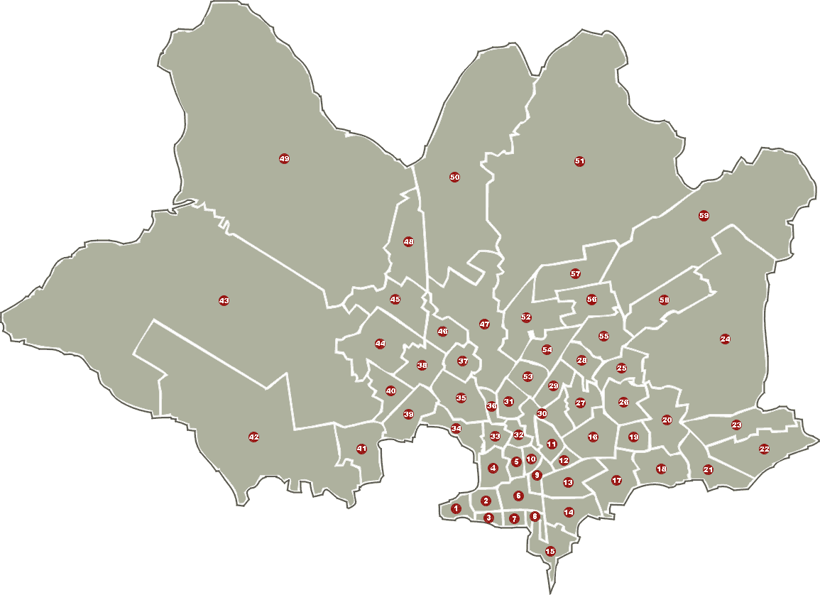
The city of Montevideo, capital of Uruguay, is divided in 62 barrios (neighbourhoods or districts), each with its own identity, demographic characteristcs and activities appropriate to the socio-cultural level of its inhabitants. Most of the outer barrios of Montevideo are in their biggest part rural areas.
In a more general usage of the word barrio, some people refer to the biggest large-scale residential complexes of Montevideo as barrios, although they do not appear as such in official lists.[1] Such are the Parque Posadas in Aires Puros, the Euskal Erría complexes in Malvin Norte and others.
Many areas of the city that are now considered barrios had geographically independent populations, that were later absorbed into the growing city. This is the case with Sayago, Pocitos, Carrasco and others. Some barrios grew out of industrial areas, such as Cerro and Nuevo París. Other areas that were considered once as barrios have been incorporated in bigger actual ones. Such are the barrio Goes,[2][3] most of which has been incorporated in Villa Muñoz, while smaller parts of it were incorporated in Aguada and La Figurita, the barrio Arroyo Seco which has been incorporated in Bella Vista, the Barrio Borro, Retiro and others. As a consequence, different maps may show differences in the number and the borders of some barrios. This list and its accompanying map follow the division in barrios of the National Institute of Statistics of Uruguay.
Contents
List of barrios

- Ciudad Vieja
- Centro
- Barrio Sur
- Aguada
- Villa Muñoz, Goes, Retiro
- Cordón
- Palermo
- Parque Rodó
- Tres Cruces
- La Comercial
- Larrañaga
- La Blanqueada
- Parque Batlle - Villa Dolores
- Pocitos
- Punta Carretas
- Unión
- Buceo
- Malvín
- Malvín Norte
- Las Canteras
- Punta Gorda
- Carrasco
- Carrasco Norte
- Bañados de Carrasco
- Flor de Maroñas
- Maroñas - Parque Guaraní
- Villa Española
- Ituzaingó
- Castro (or Pérez) Castellanos
- Mercado Modelo - Bolívar
- Brazo Oriental
- Jacinto Vera
- La Figurita
- Reducto
- Capurro - Bella Vista, Arroyo Seco
- Prado - Nueva Savona
- Atahualpa
- Aires Puros
- Paso de las Duranas
- Belvedere
- La Teja
- Tres Ombúes - Pueblo Victoria
- Villa del Cerro
- Casabó - Pajas Blancas
- La Paloma - Tomkinson, Rincón del Cerro
- Paso de la Arena - Los Bulevares - Santiago Vázquez
- Nuevo París
- Conciliación
- Sayago
- Peñarol - Lavalleja
- Colón Centro y Noroeste
- Lezica - Melilla
- Colón Sudeste - Abayubá
- Manga - Toledo Chico
- Casavalle, Barrio Borro
- Cerrito de la Victoria
- Las Acacias
- Jardines del Hipódromo
- Piedras Blancas
- Manga
- Punta de Rieles - Bella Italia
- Villa García - Manga Rural
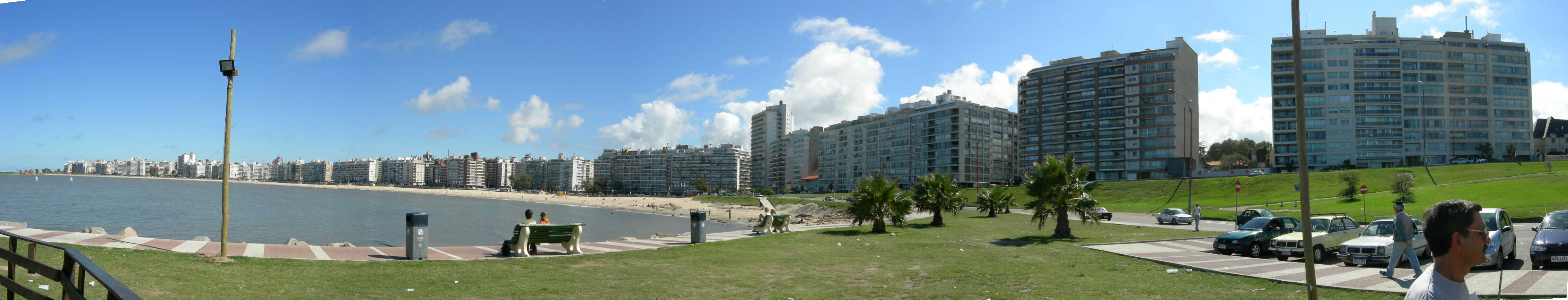
 Montevideo, Pocitos Neighborhood
See also
References
External links
Categories:- Barrios of Montevideo
- Lists of neighbourhoods
Wikimedia Foundation. 2010.