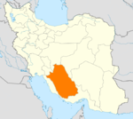
- Now Bandegan
-
Now Bandegan
نوبندگان— city — Coordinates: 28°51′15″N 53°49′33″E / 28.85417°N 53.82583°ECoordinates: 28°51′15″N 53°49′33″E / 28.85417°N 53.82583°E Country  Iran
IranProvince Fars County Fasa Bakhsh Now Bandegan Population (2006) – Total 2,933 Time zone IRST (UTC+3:30) – Summer (DST) IRDT (UTC+4:30) Now Bandegan (Persian: نوبندگان, also Romanized as Now Bandegān and Naubandagān)[1] is a city in and the capital of Now Bandegan District, in Fasa County, Fars Province, Iran. At the 2006 census, its population was 2,933, in 766 families.[2]
References
- ^ Now Bandegan can be found at GEOnet Names Server, at this link, by opening the Advanced Search box, entering "-3077153" in the "Unique Feature Id" form, and clicking on "Search Database".
- ^ "Census of the Islamic Republic of Iran, 1385 (2006)" (Excel). Islamic Republic of Iran. http://www.amar.org.ir/DesktopModules/FTPManager/upload/upload2360/newjkh/newjkh/07.xls.
 Fars Province, Iran
Capital 
Counties (A-K)
and CitiesArsanjanSurian • KorehiEqlid • SedehFiruzabad • MeymandGerash CountyKavar CountyKharameh CountyKharamehKhonj CountySafashahr • QaderabadCounties (L-Z)
and CitiesPasargad CountySaadat ShahrQir and Karzin CountyRostam CountySarvestan CountySarvestanZarrin Dasht CountyLandmarks Afif-Abad Garden · Amir's dam · Arg of Karim Khan · Barmdelak lagoon · Bishapur · Delgosha Garden · Eram Garden · Estakhr · Ghal'eh Dokhtar · Ka'ba-ye Zartosht · Kazerun fire temple · Lake Parishan · Naqsh-e Rajab · Naqsh-e Rustam · Palace of Ardashir · Pars museum · Pasargadae · Persepolis · Qavam House · Qur'an Gate · Saadi's mausoleum · Sarvestan Sassanian palace · Shah Cheragh · Colossal Statue of Shapur I in Shapur cave · Tangeh Bolaghi · Hāfezieh · Tounbbot · Vakil Bath · Vakil Bazaar · Vakil Mosque
Categories:- Fasa County
- Cities in Iran
- Cities in Fars Province
- Fars Province geography stubs
Wikimedia Foundation. 2010.

