- Tessenderlo
Infobox Belgium Municipality
name=Tessenderlo
picture=
picture-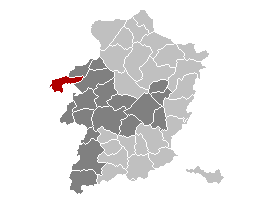
map-
arms=Tessenderlo wapen.jpg
region=BE-REG-FLE
community=BE-NL
province=BE-PROV-LI
arrondissement=Hasselt
nis=71057
pyramid-date=
0-19=
20-64=
65=
foreigners=
foreigners-date=
mayor=Jan Verheyden (sp.a)
majority=sp.a ,VLD , spirit
postal-codes=3980
telephone-area=013
web= [http://www.tessenderlo.be/ www.tessenderlo.be]
lat_deg=51
lat_min=04
lon_deg=05
lon_min=05Tessenderlo is a
municipality located in the Belgian province ofLimburg (Belgium) . It is where the three Belgian provinces ofLimburg (Belgium) ,Flemish Brabant andAntwerp (province) meet at the front gate of theAverbode Abbey. The municipality Tessenderlo encompasses the villages of Tessenderlo proper,Schoot ,Engsbergen , Hulst andBerg . It is on theAlbert Canal and theEuropean route E313 , the highway betweenAntwerp andLiège , one of the reasons why it was the place for the first Belgian "Industrial Zone of National Importance" in the 1960's.Tessenderlo was the scene of an infamous industrial disaster during WWII, when a stock of 150 tonnes of
ammonium nitrate at the chemical plant of "Produits Chimiques de Tessenderloo" (now "Tessenderlo Chemie ") - located near the centre of town - exploded on April 29th 1942, killing 189 people at the plant and in the town.Tessenderlo is part of a small western zone of Limburg where the local dialect is not the
Limburgian dialect , butBrabantic .On
January 1 2006 Tessenderlo had a total population of 16,811. The total area is 51.35 km² which gives apopulation density of 327 inhabitants per km².External links
* [http://www.tessenderlo.be Official website ] - Available only in Dutch

Wikimedia Foundation. 2010.