Nakadori Island

Nakadori Island

Coordinates: 32°59′N 129°05′E / 32.983°N 129.083°E / 32.983; 129.083

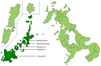
Location of Nakadōri Island (Nakadōrijima) in the Gotō Islands

Nakadōri Island[1] (中通島 Nakadōrijima?) is an island in the Gotō Islands, Japanese islands in the East China Sea, off the western coast of Kyūshū. The islands are a part of Nagasaki Prefecture in Japan. Nakadōrijima is often referred to as Kamigotō, but this is a misnomer.

Contents

Geography

The island is roughly the same shape as a left hand held with the thumb and index finger extended. Thus, it is relatively long and narrow. From Aokata, a centrally located village, it is about 30 kilometers (19 mi) through what would be your index finger to the northernmost tip of the island. This region is mostly Shinuonome Town. From Aokata through what would be the thumb, it is about 12 kilometers .5 miles) to the northeast tip of the island where a small airport is located. This region is made up of Arikawa Town. What would be the palm is made up of Arikawa and Kamigotō Towns. While these distances are relatively short, the island is very mountainous. The roads are quite narrow and very curvy. Thus, about twice the normal time is needed for driving.

History

Kamigoto has been subject to two distinct periods of prosperity. These were the era of active trade with China until the 13th century and a more recent whaling boom that lasted until about fifty years ago. Both of these periods made this small rural area quite famous throughout Japan. The island has many interesting artifacts from both of these periods.

In August 2004, the five towns which formerly made up Kamigotō merged into a new town, appropriately named Shin Kamigotō Town (Shin means "new"). The former towns are now referred to as areas or districts (chiku).

See also

  • Shinkamigotō, Nagasaki - Information of the merger of most of Nakadōrijima's towns into one 'city'.
  • Gotō Islands - Information on the Island chain that Nakadōrijima belongs to.

Sources

  • Mitchell, Thomas (September 1, 1992). Navigating Nagasaki. Nagasaki International Association. 

References

  1. ^ "Nagasaki, Unzen, Goto Islands, Iki and Tsushima" (PDF). Japan National Tourist Organization. 2007. http://www.jnto.go.jp/eng/location/rtg/pdf/pg-703.pdf. 

Wikimedia Foundation. 2010.

Игры ⚽ Нужна курсовая?

Look at other dictionaries:

  • Gotō Islands — Japanese Gotō rettō Island chain, China Sea, part of Nagasake prefecture, Japan. Lying off the western coast of Japan, the chain comprises more than 100 islands, of which 34 are inhabited. The five main ones are Fukue, Hisaka, Naru, Uku, and… …   Universalium

  • Liste japanischer Inseln — Inhaltsverzeichnis 1 Hauptinseln 2 Weitere Inseln (> 60 km²) 3 Inseln nach Inselgruppen geordnet 3.1 Inseln im Japanisches Meer …   Deutsch Wikipedia

  • Fukushima Prefecture — Infobox Prefecture Japan Name = Fukushima JapaneseName = 福島県 Rōmaji = Fukushima ken Symbol = PrefSymbol Fukushima.png Capital = Fukushima (city) Region = Tōhoku Island = Honshū TotalArea = 13,782.54 AreaRank = 3rd PCWater = 0.9 PopDate = January… …   Wikipedia

  • Bonin-Inseln — Ogasawara Inseln Die Ogasawara Inseln (jap. 小笠原諸島 Ogasawara shotō) sind eine japanische Inselgruppe, die etwa 1000 Kilometer südöstlich der japanischen Hauptinsel Honshū liegen und sich südlich an die Izu Inseln anschließen. Der Archipel wird… …   Deutsch Wikipedia

  • Bonininseln — Ogasawara Inseln Die Ogasawara Inseln (jap. 小笠原諸島 Ogasawara shotō) sind eine japanische Inselgruppe, die etwa 1000 Kilometer südöstlich der japanischen Hauptinsel Honshū liegen und sich südlich an die Izu Inseln anschließen. Der Archipel wird… …   Deutsch Wikipedia

  • Ogasawara-Inselkette — Ogasawara Inseln Die Ogasawara Inseln (jap. 小笠原諸島 Ogasawara shotō) sind eine japanische Inselgruppe, die etwa 1000 Kilometer südöstlich der japanischen Hauptinsel Honshū liegen und sich südlich an die Izu Inseln anschließen. Der Archipel wird… …   Deutsch Wikipedia

  • Minamisōma, Fukushima — Minamisōma 南相馬市   City   Minamisoma City Office …   Wikipedia

  • Ogasawara-guntō — (Bonininseln) Satellitenbild der Inselgruppe Gewässer Pazifischer Ozean …   Deutsch Wikipedia

Share the article and excerpts

Direct link
Do a right-click on the link above
and select “Copy Link”