- New York State Route 3A
-
This article is about the current alignment of NY 3A. For previous alignments of NY 3A, see New York State Route 3A (disambiguation).
NYS Route 3A 
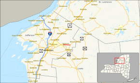
Map of the Jefferson County area with NY 3A highlighted in redRoute information Maintained by Jefferson County Length: 5.19 mi[3] (8.35 km) Existed: early 1950s[1][2] – present Major junctions West end:  NY 3 in Deferiet
East end:  NY 3 in Wilna
Location Counties: Jefferson Highway system Numbered highways in New York
Interstate • U.S. • N.Y. (former) • Reference • County←  NY 3
NY 3US 4  →
→New York State Route 3A (NY 3A) is a county-maintained state highway in Jefferson County, New York, United States. The route is an alternate route of NY 3 between the village of Deferiet and Fargo, a hamlet within the town of Wilna. While NY 3 veers south to serve the village of Carthage, NY 3A follows a direct east–west alignment between the two communities. The eastern half of the route passes through the Fort Drum limits. All of NY 3A is co-designated as County Route 36 and is co-signed as such.
The origins of the route date back to the 1930s when it was first designated as part of NY 3. The alignments of NY 3 and New York State Route 3G between Deferiet and Fargo were flipped ca. 1938, placing NY 3 on its modern alignment via Carthage and NY 3G on modern NY 3A. The NY 3G designation was eliminated in the 1940s. Its former alignment went unnumbered until the early 1950s when it was redesignated as NY 3A.
Contents
Route description
NY 3A begins at an intersection with NY 3 in the village of Deferiet. It heads northeastward, passing to the south of the village center as it heads through an undeveloped area of the community. It continues across a small canal and past a chemical plant before turning eastward and leaving the Deferiet village limits. The route heads on through the town of Wilna, passing through a small, unnamed community built up around County Route 37 and little else before entering the limits of Fort Drum. While in Fort Drum, NY 3A heads through a dense forest as it heads across an area with no development whatsoever. This trend finally ceases in the small hamlet of Fargo, where NY 3A passes by a handful of buildings before ending at another junction with NY 3.[4] All of NY 3A is maintained by Jefferson County; as a result, it is co-designated and co-signed as County Route 36.[5][6]
History
NY 3 originally went through Carthage on its way from Deferiet to Fargo.[7] It was realigned ca. 1931 to bypass Carthage to the north on modern NY 3A. The former routing of NY 3 between Deferiet and Carthage was originally designated as NY 3F; however, it was redesignated as NY 3G by the following year.[8][9] Ca. 1938, NY 3 was moved back to the Deferiet–Carthage–Fargo alignment while the NY 3G designation was transferred to the former routing of NY 3 between Deferiet and Fargo.[10][11] The NY 3G designation was removed in the 1940s.[12][13] Its former routing remained unnumbered until the early 1950s when it was redesignated as NY 3A.[1][2]
Major intersections
The entire route is in Jefferson County.
Location Mile[3] Destinations Notes Deferiet 0.00  NY 3
NY 3Wilna 5.19  NY 3
NY 3Hamlet of Fargo 1.000 mi = 1.609 km; 1.000 km = 0.621 mi References
- ^ a b Sunoco (1952). New York (Map). Cartography by Rand McNally and Company.
- ^ a b Esso (1954). New York with Special Maps of Putnam–Rockland–Westchester Counties and Finger Lakes Region (Map). Cartography by General Drafting (1955–56 ed.).
- ^ a b "2008 Traffic Data Report for New York State" (PDF). New York State Department of Transportation. June 16, 2009. p. 85. https://www.nysdot.gov/divisions/engineering/technical-services/hds-respository/NYSDOT_Traffic_Data_Report_2008.pdf. Retrieved December 27, 2009.
- ^ Yahoo! Inc. Yahoo! Maps – overview map of NY 3A (Map). Cartography by NAVTEQ. http://maps.yahoo.com/#mvt=h&lat=44.034165&lon=-75.63219&zoom=15&q1=44.032666%2C-75.683423&q2=44.0338%2C-75.580963. Retrieved December 27, 2009.
- ^ New York State Department of Transportation (1996). Deferiet Digital Raster Quadrangle (Map). 1:24,000. http://www.nysgis.state.ny.us/gisdata/quads/drg24/dotpreview/index.cfm?code=h33. Retrieved December 27, 2009.
- ^ New York State Department of Transportation (1996). North Wilna Digital Raster Quadrangle (Map). 1:24,000. http://www.nysgis.state.ny.us/gisdata/quads/drg24/dotpreview/index.cfm?code=h34. Retrieved December 27, 2009.
- ^ Standard Oil Company of New York (1930). Road Map of New York (Map). Cartography by General Drafting.
- ^ Standard Oil Company (1931). New York (Map). Cartography by General Drafting.
- ^ Texas Oil Company (1932). Texaco Road Map – New York (Map). Cartography by Rand McNally and Company.
- ^ Standard Oil Company (1937). New York (Map). Cartography by General Drafting.
- ^ Thibodeau, William A. (1938). The ALA Green Book (1938–39 ed.). Automobile Legal Association.
- ^ Esso (1942). New York with Pictorial Guide (Map). Cartography by General Drafting.
- ^ State of New York Department of Public Works. Official Highway Map of New York State (Map). Cartography by General Drafting (1947–48 ed.).
External links
Categories:- State highways in New York
- Transportation in Jefferson County, New York
Wikimedia Foundation. 2010.

