- Maamorilik
-
Maamorilik (old spelling: Mârmorilik or Maarmorilik, also Black Angel Mine) is a mining site in the Qaasuitsup municipality in northwestern Greenland. Holding resources of zinc, iron, lead, and silver,[1][2] the mine is 5 km (3.1 mi) long,[3] with its entry level situated 750 m (2,460 ft) above the sea level.[4]
Contents
Geography
The mine is located approximately 24 km (15 mi) northeast of Ukkusissat in the Akuliarusikassak massif on the mainland of Greenland, on the southern shore of the Qaumarujuk Fjord, a tributary fjord of Perlerfiup Kangerlua, an inner branch of the Uummannaq Fjord.[5]
History
The first excavations in Maamorilik took place in 1973,[3] with operations continuing until 25 July 1990,[6] when the mine was closed. During seventeen years of operation, the mine yield of zinc ore amounted to 12 mln tonnes.[3]
Reactivation
In 2008[6] the government of Greenland decided to reinvigorate mining activities in Maamorilik, aiming to provide an economic lifeline to the communities of the Uummannaq region,[7] keeping the relatively new Qaarsut Airport open.[8] Proceeds from mineral resources exploitation will provide Greenland with a counterbalance to the lump-sum subsidies from Denmark.
The operations are carried out by Angel Mining plc, a UK-registered company.[3] As of April 2010, work continues on widening of the mine entrance to the required 300 m (980 ft).[4] The mine is due to reopen in November 2010,[4] with zinc and iron ore reserves expected to last for 50 years.[9] Prospective employment is estimated at 110 people.[10]
Transport
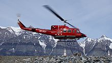
 Air Greenland provides charter supply flights to the mining site. Photographed during takeoff in Ukkusissat
Ukkusissat Heliport is the closest aerodrome to the mining site, approximately 24 km (15 mi) to the southwest. As in the 1970s,[11] supplies for the mine reconstruction are carried out via Air Greenland charter flights, now operated with the Bell 212 helicopter stationed in Uummannaq Heliport, 42 km (26 mi) away.[12]
Coordinates: 71°07′35″N 51°16′40″W / 71.12639°N 51.27778°W
References
- ^ Bureau of Minerals and Petroleum
- ^ "Resources and Industry". Government of Greenland. http://uk.nanoq.gl/Emner/About/Resources_and_industry.aspx. Retrieved 17 May 2010.
- ^ a b c d Angel Mining plc
- ^ a b c "Maarmorilik udvides" (in Danish). Kalaallit Nunaata Radioa. 27 April 2010. http://www.knr.gl/index.php?id=183&tx_ttnews%5Btt_news%5D=55598&cHash=fde878b4e3. Retrieved 17 May 2010.
- ^ Tage Schjøtt, Denmark. Nuussuaq (Map) (1992 ed.).
- ^ a b Greenland Employers Association
- ^ "Future of lead mine uncertain". Sermitsiaq. http://sermitsiaq.gl/english/newsletter/weeklynewsletter/articles/article57900.ece. Retrieved 17 May 2010.
- ^ "Lufthavne bliver ikke lukket" (in Danish). Sermitsiaq. 17 October 2007. http://sermitsiaq.gl/politik/article18567.ece. Retrieved 17 May 2010.
- ^ "Maarmorilik har zink og jern til 50 år" (in Danish). Kalaallit Nunaata Radioa. 27 April 2010. http://www.knr.gl/index.php?id=4532&tx_ttnews%5Btt_news%5D=55642&tx_ttnews%5BbackPid%5D=6779&cHash=5e98642c37. Retrieved 17 May 2010.
- ^ "Maarmorilik genåbnes i år" (in Danish). Sermitsiaq. 11 January 2008. http://sermitsiaq.gl/erhverv/article27313.ece. Retrieved 17 May 2010.
- ^ "Grønlandsfly 1970-79" (in Danish). Air Greenland. http://50.airgreenland.dk/70'erne/. Retrieved 17 May 2010.
- ^ "Black Angel News, the newsletter about the Black Angel Project in Greenland". Angelmining plc. http://www.angelmining.com/assets/files/BAM-News-3.pdf. Retrieved 19 May 2010.
External links
Categories:- Iron mines in Greenland
- Lead mines in Greenland
- Silver mines in Greenland
- Uummannaq Fjord
- Zinc mines in Greenland
Wikimedia Foundation. 2010.

