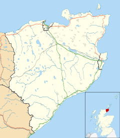
Mybster

Mybster

Coordinates: 58°27′08″N 3°25′31″W / 58.45236°N 3.42525°W / 58.45236; -3.42525

Mybster
Mybster is located in Caithness
Mybster

 Mybster shown within the Caithness area
OS grid reference ND169524
Council area Highland
Country Scotland
Sovereign state United Kingdom
Post town Wick
Postcode district KW1 5
Police Northern
Fire Highlands and Islands
Ambulance Scottish
EU Parliament Scotland
List of places: UK • Scotland •

Mybster is a small village, in Caithness, Scottish Highlands and is in the Scottish council area of Highland.

Mybster lies 2 miles northwest of the Loch of Toftingall, with the village of Watten lying 2 miles directly to the east, and Thurso located 7 miles north along the A9 road.

References


Wikimedia Foundation. 2010.

Игры ⚽ Нужно решить контрольную?

Look at other dictionaries:

  • A9 road (Scotland) — The A9 is a major road running from the Falkirk council area in central Scotland to Thurso in the far north, via Stirling, Bridge of Allan, Perth and Inverness. At 273 miles, it is the longest road in Scotland and the fifth longest A road in the… …   Wikipedia

  • List of places in Highland Region — This is a list of cities, towns and villages in Highland Region in Scotland Highland Region is not to be confused with the Scottish Highlands, which have very different boundaries.compactTOC NOTOC A* Achriesgill, Achiemore, Achimore, Achina,… …   Wikipedia

  • List of places in Highland — This article is a list of links for any town, village, hamlet and settlements, in the Highland council area in Scotland. The area encompassed by the Highland council is a slightly different area to that encompassed by the Scottish… …   Wikipedia

Share the article and excerpts

Direct link
Do a right-click on the link above
and select “Copy Link”