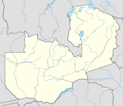
- Mutanda, Zambia
-
Mutanda — Town — Location of Mutanda in Zambia Coordinates: 12°24′00″S 26°14′24″E / 12.4°S 26.24°E Country  Zambia
Admin. division Northwestern Province Elevation 4,265 ft (1,300 m) Population (2010 (Estimate)) – Total 2,000 Mutanda is a town in Zambia.
Contents
Location
Mutanda is located in Solwezi District, Northwestern Zambia. This location is approximately 33 kilometres (21 mi), by road, southwest of Solwezi, where the district headquarters are located.[1] Mutanda is situated approximately 500 kilometres (310 mi), by road, northwest of Lusaka, the capital and largest city in Zambia.[2] The coordinates of the town are:12 24 00S, 26 14 24E (Latitude:-12.4000; Longitude:26.2400).[3]
Population
As of December 2010[update], the population of Mutanda is estimated at about 2,000 people.[4]
Landmarks
In Mutanda, or near its borders, there are the following landmarks:[5]
- Mutanda Evangelical Mission
- Mutanda Mini Hydropower Station - 2kW
- Mutanda Electricity Utility Company
- The junction of Chingola-Ikelenge Highway (T5) with the Zambezi-Mutanda Highway (M8)
- River Mutanda - The river runs through the town, dividing it into East Mutanda and West Mutanda.
- Mutanda Hospital
- Mutanda High School - Mixed, residential high school
- Mutanda Primary School - Mixed, elementary non-residential school
See also
External links
References
Categories:- Populated places in Zambia
- Northwestern Province, Zambia
Wikimedia Foundation. 2010.

