- Hatbox Field
-
Hatbox Field
(closed)
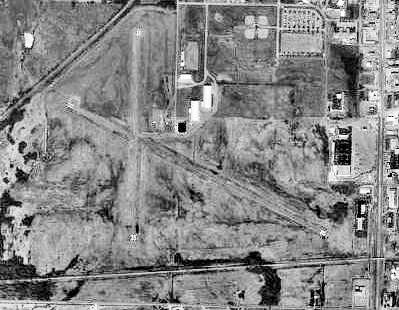
USGS aerial image, 1995 IATA: HAX – ICAO: KHAX – FAA LID: HAX Summary Airport type Public Owner City of Muskogee Serves Muskogee, Oklahoma Elevation AMSL 627 ft / 191 m Coordinates 35°44′45″N 095°24′46″W / 35.74583°N 95.41278°W Runways Direction Length Surface ft m 11/29 3,800 1,158 Asphalt Source: Federal Aviation Administration[1] 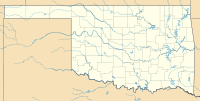
 Hatbox FieldLocation of Hatbox Field, Oklahoma
Hatbox Field (IATA: HAX, ICAO: KHAX, FAA LID: HAX) is a closed airfield located within city limits, two nautical miles (3.7 km) west of central Muskogee, a city in Muskogee County, Oklahoma, United States.[1] It was opened sometime in the early 1920s and was closed in 2000. It is presently the location of the Love-Hatbox Sports Complex, a large recreation center and waterpark.
The former airfield site includes 10 lighted baseball fields‚ eight lighted softball diamonds‚ two full-size football fields and a 30 acre‚ 19-field soccer area called the Georgia Pacific Soccer Complex.
In addition‚ a 3.1-mile (5K) asphalt Centennial Trail walking/biking exercise pathway loops around the 120 acres‚ and a former airplane hangar houses three indoor batting cages. Three Rivers Area Model Plane Society (T.R.A.M.P.S.), a local model airplane club, hosts two annual events at Love-Hatbox that attract flying enthusiasts from around the country.
Contents
History
Hatbox Field was depicted on the 1929 Rand McNally "Standard Indexed Map with Air Trails of OK" as a public airport with a radio station. The airfield was Muskogee's original municipal airport, and is a very historic airfield. It is one of the airports that the Douglas aircraft of the Army's 1924 Around the World Flight stopped, and was a stop on the Army's mail route.
In 1929, the airfield was described as a municipal airport, operated by the Army Air Corps, and having a beacon light. Charles Lindbergh was on hand for the dedication.
The Spartan Aviation School opened at the field in 1940. They used the 2 large arch-roofed hangars at Hatbox. Renamed Muskogee Army Airfield during World War II, Spartan provided primary flight training to cadets as an Army Air Forces contract flying school until 1944. The USAAF 410th Bombardment Group trained at the airfield with Douglas A-20 Havocs in the fall of 1943 before being reassigned to the Ninth Air Force in England, where they flew Martin B-26 Marauders.
Following the end of its military use, Hatbox was reused as a purely civil airfield. The operator was listed as the City of Muskogee.
The city of Muskogee decided to close the field to the public following a two-fatality crash in 1998. Limited aviation use was allowed until 2000, however, by a private firm that refurbished military-surplus Beechcraft U-21 Utes. Hatbox was closed completely in 2000, and the refurbishing company moved to nearby Muskogee Davis Field.
Facilities
Hatbox Field covered an area of 434 acres (176 ha) at an elevation of 627 feet (191 m) above mean sea level. It had one runway designated 11/29 with an asphalt surface measuring 3,800 by 50 feet (1,158 x 15 m).[1]
See also
References
- ^ a b c FAA Airport Master Record for HAX (Form 5010 PDF). Federal Aviation Administration. Effective 29 July 2010.
Other sources
 This article incorporates public domain material from websites or documents of the Air Force Historical Research Agency.
- Shaw, Frederick J. (2004), Locating Air Force Base Sites History’s Legacy, Air Force History and Museums Program, United States Air Force, Washington DC, 2004.
- Manning, Thomas A. (2005), History of Air Education and Training Command, 1942–2002. Office of History and Research, Headquarters, AETC, Randolph AFB, Texas ASIN: B000NYX3PC
- Maurer, Maurer (1983). Air Force Combat Units Of World War II. Maxwell AFB, Alabama: Office of Air Force History. ISBN 0-89201-092-4.
- Abandoned & Little-Known Airfields: Eastern Oklahoma
External links
- Encyclopedia of Oklahoma History and Culture - Hatbox Field
- Three Rivers Area Model Plane Society
- Resources for this airport:
- AirNav airport information for HAX
- ASN accident history for HAX
- FlightAware airport information and live flight tracker
- SkyVector aeronautical chart for HAX
 Army Air Forces Training Command
Flying Training Flying Schools Eastern Flying Training Command · Central Flying Training Command · Western Flying Training CommandSpecialized Schools Bombardier · Contract Flying · Glider Training · Gunnery · Navigator
Technical Training Eastern Technical Training Command · Central Technical Training Command · Western Technical Training Command USAAF Third Air Force in World War IIAirfields Group Training Stations · Replacement Training Stations · Tactical Airfields
Units Commands II Air Support Command · III Air Support Command · III Bomber Command · III Fighter Command · III Reconnaissance Command · III Tactical Air CommandDivisions III Tactical Air DivisionWings 8th Fighter Wing · 9th Fighter Wing · 40th Bombardment WingGroups Air Commando 2nd Air Commando · 3rd Air CommandoBombardment 3rd Bombardment · 12th Bombardment · 17th Bombardment · 21st Bombardment · 29th Bombardment · 30th Bombardment Group · 38th Bombardment · 44th Bombardment · 46th Bombardment · 47th Bombardment · 85th Bombardment · 88th Bombardment · 90th Bombardment · 91st Bombardment · 92nd Bombardment · 93rd Bombardment · 94th Bombardment · 95th Bombardment · 97th Bombardment · 98th Bombardment · 99th Bombardment · 100th Bombardment · 309th Bombardment · 310th Bombardment · 312th Bombardment · 319th Bombardment · 320th Bombardment · 321st Bombardment · 322d Bombardment · 323d Bombardment · 335th Bombardment · 336th Bombardment · 340th Bombardment · 344th Bombardment · 345th Bombardment · 386th Bombardment · 387th Bombardment · 391st Bombardment · 394th Bombardment · 396th Bombardment · 397th Bombardment · 409th Bombardment · 410th Bombardment · 411th Bombardment · 416th Bombardment · 417th Bombardment · 418th Bombardment · 451st Bombardment · 454th Bombardment · 463rd Bombardment · 483rd Bombardment · 488th BombardmentFighter 20th Fighter · 31st Fighter · 49th Fighter · 50th Fighter · 53rd Fighter · 54th Fighter · 56th Fighter · 59th Fighter · 79th Fighter · 80th Fighter · 81st Fighter · 84th Fighter · 85th Fighter · 311th Fighter · 332nd Fighter · 337th Fighter · 338th Fighter · 339th Fighter · 361st Fighter · 369th Fighter · 372nd Fighter · 404th Fighter · 405th Fighter · 408th Fighter · 414th Fighter · 506th FighterFighter-Bomber 27th Fighter-Bomber · 48th Fighter-Bomber · 86th Fighter-Bomber · 406th Fighter-Bomber · 407th Fighter-BomberReconnaissance 2d Reconnaissance · 9th Reconnaissance · 10th Reconnaissance · 26th Reconnaissance · 65th Reconnaissance · 67th Reconnaissance · 68th Reconnaissance · 69th Reconnaissance · 70th Reconnaissance · 75th Reconnaissance · 77th Reconnaissance · 423d Reconnaissance · 424th Reconnaissance · 426th ReconnaissanceCategories:- 1929 establishments
- Airfields of the United States Army Air Forces in Oklahoma
- Airports in Oklahoma
- Muskogee, Oklahoma
- USAAF Contract Flying School Airfields
- USAAF Third Air Force Group Training Stations
- Buildings and structures in Muskogee County, Oklahoma


Wikimedia Foundation. 2010.