- Mozdoksky District
-
Mozdoksky District (English)
Моздокский район (Russian)
Мæздæджы район (Ossetic)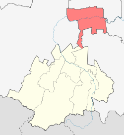
Location of Kirovsky District on the map of the Republic of North Ossetia-AlaniaAdministrative status (as of 2009) Country Russia Federal subject Republic of North Ossetia–Alania[1] Administrative center town of Mozdok[2] Statistics Population (2010 Census,
preliminary)84,642 inhabitants[3] Population (2002 Census) 88,634 inhabitants[4] - Urban population 48.4% - Rural population 51.6% Time zone [5] Mozdoksky District (Russian: Моздокский райо́н; Ossetic: Мæздæджы район) is an administrative and municipal district (raion), one of the eight in the Republic of North Ossetia–Alania, Russia. It is located in the northern portion of the republic. Its administrative center is the town of Mozdok.[2] District's population: 84,642 (2010 Census preliminary results);[3] 88,634 (2002 Census);[6] 77,063 (1989 Census).[7] Population of Mozdok accounts for 45.8% of the district's population.[3]
References
- ^ Constitution, Article 64.3
- ^ a b Law #34-RZ, Appendix
- ^ a b c Федеральная служба государственной статистики (Federal State Statistics Service) (2011). "Предварительные итоги Всероссийской переписи населения 2010 года (Preliminary results of the 2010 All-Russian Population Census)" (in Russian). Всероссийская перепись населения 2010 года (All-Russia Population Census of 2010). Federal State Statistics Service. http://www.perepis-2010.ru/results_of_the_census/results-inform.php. Retrieved 2011-04-25.
- ^ Федеральная служба государственной статистики (Federal State Statistics Service) (2004-05-21). "Численность населения России, субъектов Российской Федерации в составе федеральных округов, районов, городских поселений, сельских населённых пунктов – районных центров и сельских населённых пунктов с населением 3 тысячи и более человек (Population of Russia, its federal districts, federal subjects, districts, urban localities, rural localities—administrative centers, and rural localities with population of over 3,000)" (in Russian). Всероссийская перепись населения 2002 года (All-Russia Population Census of 2002). Federal State Statistics Service. http://www.perepis2002.ru/ct/doc/1_TOM_01_04.xls. Retrieved 2010-03-23.
- ^ Правительство Российской Федерации. Постановление №725 от 31 августа 2011 г. «О составе территорий, образующих каждую часовую зону, и порядке исчисления времени в часовых зонах, а также о признании утратившими силу отдельных Постановлений Правительства Российской Федерации». Вступил в силу по истечении 7 дней после дня официального опубликования. Опубликован: "Российская Газета", №197, 6 сентября 2011 г. (Government of the Russian Federation. Resolution #725 of August 31, 2011 On the Composition of the Territories Included into Each Time Zone and on the Procedures of Timekeeping in the Time Zones, as Well as on Abrogation of Several Resolutions of the Government of the Russian Federation. Effective as of after 7 days following the day of the official publication).
- ^ Федеральная служба государственной статистики (Federal State Statistics Service) (2004-05-21). "Численность населения России, субъектов Российской Федерации в составе федеральных округов, районов, городских поселений, сельских населённых пунктов – районных центров и сельских населённых пунктов с населением 3 тысячи и более человек (Population of Russia, its federal districts, federal subjects, districts, urban localities, rural localities—administrative centers, and rural localities with population of over 3,000)" (in Russian). Всероссийская перепись населения 2002 года (All-Russia Population Census of 2002). Federal State Statistics Service. http://www.perepis2002.ru/ct/doc/1_TOM_01_04.xls. Retrieved 2010-03-23.
- ^ "Всесоюзная перепись населения 1989 г. Численность наличного населения союзных и автономных республик, автономных областей и округов, краёв, областей, районов, городских поселений и сёл-райцентров. (All Union Population Census of 1989. Present population of union and autonomous republics, autonomous oblasts and okrugs, krais, oblasts, districts, urban settlements, and villages serving as district administrative centers.)" (in Russian). Всесоюзная перепись населения 1989 года (All-Union Population Census of 1989). Demoscope Weekly (website of the Institute of Demographics of the State University—Higher School of Economics. 1989. http://demoscope.ru/weekly/ssp/rus89_reg.php. Retrieved 2010-03-23.
Sources
- Верховный Совет Республики Северная Осетия. 12 ноября 1994 г. «Республика Северная Осетия-Алания. Конституция.», в ред. Конституционного Закона №7-РКЗ от 22 декабря 2006 г «О внесении изменений в Конституцию Республики Северная Осетия-Алания». Вступил в силу 7 декабря 1994 г. Опубликован: брошюрой "Конституция Республики Северная Осетия-Алания". (Supreme Council of the Republic of North Ossetia. November 12, 1994 Republic of North Ossetia-Alania. Constitution., as amended by the Constitutional Law #7-RKZ of December 22, 2006 On Amending the Constitution of the Republic of North Ossetia-Alania. Effective as of December 7, 1994).
- Закон №34-РЗ от 9 июля 2007 г. «Об административно-территориальном устройстве Республики Северная Осетия-Алания». Вступил в силу со дня официального опубликования. Опубликован: газета "Северная Осетия", №148(24949), 16 августа 2007 г. (Law #34-RZ of July 9, 2007 On the Administrative and Territorial Structure of the Republic of North Ossetia-Alania. Effective as of the official publication date).
Administrative divisions of the Republic of North Ossetia–Alania Capital: Vladikavkaz
Cities and towns 
Administrative districts Categories:- Districts of North Ossetia-Alania

Wikimedia Foundation. 2010.