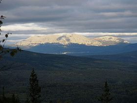
- Mount Yamantau
-
Mount Yamantau 
Elevation 1,640 m (5,381 ft) Location Location Republic of Bashkortostan, Russia Range Ural Mountains Coordinates 54°15′18″N 58°06′07″E / 54.255°N 58.102°E Mount Yamantaw Part of Armed Forces of the Russian Federation Mezhgorye, Republic of Bashkortostan, Russia Type Underground military facility Coordinates 54°15′18″N 58°06′07″E / 54.255°N 58.102°ECoordinates: 54°15′18″N 58°06′07″E / 54.255°N 58.102°E Built Under construction (2003) In use Unknown Current
conditionUnknown Controlled by Armed forces of the Russian Federation Garrison Mezhgorye Occupants Unknown Mount Yamantau (Russian: гора Ямантау) is in the Ural Mountains, Bashkortostan, Russia. The name means bad (evil) mountain in the Bashkir language (Яман тау). It is also known as Mount Yamantaw[citation needed]. It stands at 1,640 metres (5,381 ft) and is the highest mountain in the southern Urals. Along with Kosvinsky Mountain (600 km to the north), it is suspected by the United States of being a large secret nuclear facility and/or bunker.[1] The closed military town of Mezhgorye (Russian: Межгорье) is situated nearby. As late as 2003, Yamantaw was not yet fully operational.[1]
“ The only potential use for this site is post-nuclear war.[2][3] ” —Rep. Roscoe Bartlett
Large excavation projects have been observed by U.S. satellite imagery as recently as the late 1990s, during the time of Boris Yeltsin's government after the fall of the Soviet Union.[1] Two garrisons, Beloretsk-15 and Beloretsk-16, were built on top of the facility, and possibly a third, Alkino-2, as well, and became the closed town of Mezhgorye in 1995. They are said to house 30,000 workers each. Repeated U.S. questions have yielded several different responses from the Russian government regarding Mount Yamantaw.[4] They have said it is a mining site, a repository for Russian treasures, a food storage area, and a bunker for leaders in case of nuclear war.[5] Responding to questions regarding Yamantaw in 1996, Russia's Defense Ministry stated: "The practice does not exist in the Defense Ministry of Russia of informing foreign mass media about facilities, whatever they are, that are under construction in the interests of strengthening the security of Russia."[5] Large rail lines serve the facility.[5]
Mount Yamantaw is near one of Russia's last remaining nuclear labs, Chelyabinsk-70, raising speculation that it already houses nuclear weapons. Russian newspapers reported in 1996 that it is a part of the "Dead Hand" nuclear retaliatory command structure.
See also
References
- ^ a b c Blair, Bruce G (May 25, 2003). "We Keep Building Nukes For All the Wrong Reasons". The Washington Post. http://www.cdi.org/russia/johnson/7198.htm. Retrieved 28 February 2009.
- ^ Code Red, Biblioteca Pleyades, http://www.bibliotecapleyades.net/hercolobus/planetX/code_red/code_red19.htm.
- ^ Yamantau mountain complex, Russia, The Living Moon, http://www.thelivingmoon.com/45jack_files/03files/Yamantau_Mountain_Complex_Russia.html.
- ^ "Yamantau, Beloretsk-15, Beloretsk-16, Alkino-2", Weapons of Mass Destruction, Global Security, http://www.globalsecurity.org/wmd/world/russia/yamantau.htm.
- ^ a b c Gordon, Michael R. (April 16, 1996). "Despite Cold War's End, Russia Keeps Building a Secret Complex". The New York Times. http://query.nytimes.com/gst/fullpage.html?res=9C06E4DF1E39F935A25757C0A960958260. Retrieved 28 February 2009.
External links
Categories:- Bashkortostan
- Cold War
- Fortification
- Military installations of Russia
- Mountains of Russia
- Nuclear bunkers
- Secret military programs
- Secret places
- Strategic Rocket Forces
Wikimedia Foundation. 2010.
