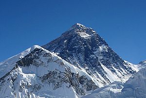
- Mount Everest webcam
-
The Mount Everest webcam is a camera located on Kala Patthar, a mountain in the Nepalese Himalaya, at an altitude of 5,675 metres (18,619 ft). The webcam captures video footage of the summit of Mount Everest[1] and is the highest webcam in the world.[1] It was installed by Italian scientists as part of the Everest Share 2011 research project by the Nepalese Ev-K2-CNR team,[2] which is intended to gather information regarding climate change by working together with the Everest weather station.
Contents
Features
The camera is an M12-type model made by the German-based company Mobotix.[2] It is powered by solar cells and operates from 6am to 6pm local time[1] (UTC +5:45). It is capable of operating at temperatures as low as −30 °C (−22 °F) and broadcasts its live high definition video worldwide via the internet.[2][3] It is expected to work in conjunction with the Everest weather station – located at an altitude of 8,000 m (26,250 ft) on Mount Everest – to provide scientists with details regarding climate change.[3]
Operation
The captured video is transmitted wirelessly to the Ev-K2-CNR Pyramid Laboratory/Observatory, located on the slopes of Mount Everest at an altitude of 5,050 m (16,568 ft). The live video is analyzed in the observatory, then sent to Italy for further processing.[2]
Location
Kala Patthar was chosen as the location for the webcam because of its excellent view of the summit of Mount Everest, including both the north and south-west faces as well as the west ridge.[2]
Highest webcam
As of May 17, 2011[4], it is the highest webcam in the world.[1] When installed, it surpassed the previous record holder, a base camp at Mount Aconcagua, Argentina, at an altitude of 4,389 m (14,400 ft).[3][5]
References
- ^ a b c d Connelly, Claire (September 30, 2011). "Mount Everest webcam gives new meaning to high-def". Herald Sun. http://www.heraldsun.com.au/technology/aint-no-mountain-high-enough-webcam-streams-video-from-top-of-mount-everest/story-fn7celvh-1226153560068. Retrieved Sep 30, 2011.
- ^ a b c d e Quick, Darren (September 30, 2011). "Researchers install world’s highest webcam to provide a view of Everest". Gizmag. http://www.gizmag.com/worlds-highest-webcam/20004/. Retrieved Sep 30, 2011.
- ^ a b c News Desk (September 30, 2011). "Solar-powered webcam brings Mount Everest to your laptop". TruthDive. http://truthdive.com/2011/09/30/Solar-powered-webcam-brings-Mount-Everest-to-your-laptop.html. Retrieved Sep 30, 2011.
- ^ Nepal Mountain News (May 24, 2011). "Webcam to zoom Everest around globe". http://www.nepalmountainnews.com/cms/?p=27587. Retrieved Aug 4, 2011.
- ^ Kidman, Alex (September 30, 2011). "There’s A Solar Powered Webcam Near The Top Of Mount Everest". Gizmodo. http://www.gizmodo.com.au/2011/09/theres-a-solar-powered-webcam-near-the-top-of-mount-everest/. Retrieved Sep 30, 2011.
External link
Categories:- Mount Everest
- Webcams
Wikimedia Foundation. 2010.

