- Mount Cramer
-
Mount Cramer 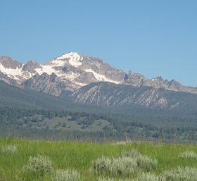
Mount CramerElevation 10,716 ft (3,266 m) [1] Location Location Custer and Boise Counties, Idaho, USA Range Sawtooth Range Coordinates 44°00′40.13″N 114°58′56.97″W / 44.0111472°N 114.9824917°WCoordinates: 44°00′40.13″N 114°58′56.97″W / 44.0111472°N 114.9824917°W[1] Climbing Easiest route Scramble - Class 3 Mount Cramer, at 10,716 feet (3,266 m) high is the second highest peak in the Sawtooth Range of Idaho. The top of Mount Cramer is located on the border of Custer and Boise Counties. The peak is the highest point in Boise County. Mount Cramer is also located within the Sawtooth Wilderness portion of the Sawtooth National Recreation Area. The town of Stanley, Idaho is almost 14 miles (23 km) from Mount Cramer, while the area known as Sawtooth City is nearly 12 miles (19 km) from Mount Cramer. The west side of Mount Cramer drains into the South Fork of the Payette River, while the east side drains to the Salmon River.
Mount Cramer can be climbed in one day via the Hell Roaring Lake Trailhead, which is located 5 miles (8.0 km) down unmaintained Sawtooth National Forest road 398, west of Idaho Route 75. The last section of the 16-mile (26 km) hike and class 3 scramble is off-trail.
References
- ^ a b "Mount Cramer". summitpost.org. http://www.summitpost.org/mountain/rock/152308/mount-cramer.html. Retrieved 2008-10-25.
External links
- Peak Bagger - Thompson Peak
- SummitPost.org - Thompson Peak
- Idaho Summits - Mount Cramer
- Sawtooth National Forest - Official Site
Categories:- Landforms of Boise County, Idaho
- Landforms of Custer County, Idaho
- Mountains of Idaho
- Idaho geography stubs

Wikimedia Foundation. 2010.