Mosquito Creek (Virginia)
- Mosquito Creek (Virginia)
-
| Mosquito Creek |

Mosquito Creek |
| Origin |
Cockle Creek |
| Mouth |
Chincoteague Bay |
| Basin countries |
United States |
| Length |
2 miles |
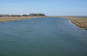
Mosquito Creek is a stream in Chincoteague, Virginia that connects with Cockle Creek to the south and a mouth at Chincoteague Bay to the North.[1]
History
The name of the creek first appeared in the Decisions of the United States Board on Geographical Names in 1943.[2]
See also
References
- ^ GMCO Maps & Charts. GMCO's Fishing & Recreation Map of Chincoteague-Assateague, Virginia, 2003.
- ^ Topping, Mary, comp., Approved Place Names in Virginia: An Index to Virginia Names Approved by the United States Board on Geographic Names through 1969 (Charlottesville, VA: University Press of Virginia, 1971), 105.
37°18′20″N 79°04′00″W / 37.30556°N 79.0666667°W / 37.30556; -79.0666667
Categories:
- Chincoteague, Virginia
- Rivers of Virginia
- Geography of Accomack County, Virginia
- Accomack County, Virginia geography stubs
Wikimedia Foundation.
2010.
Look at other dictionaries:
Mosquito Creek — may refer to: Mosquito Creek (Feather River), a California tributary of the North Fork Feather River Mosquito Creek (Iowa), a tributary of the Missouri River Mosquito Creek (Lake Oroville), a California tributary of the Feather River source… … Wikipedia
History of Virginia — The recorded History of Virginia began with settlement of the geographic region now known as the Commonwealth of Virginia in the United States thousands of years ago by Native Americans. Permanent European settlement did not occur until the… … Wikipedia
Fauna of West Virginia — Fauna of West VirginiaThe life zones of West Virginia transitions from large low land farming valleys bordered with forest and meadow to high land ridge flats and heavy forestlands, some with rocky ridge line peaks. The geology allows for a… … Wikipedia
Troop engagements of the American Civil War, 1862 — Troop engagements in 1862January;1:;Port Royal, South Carolina::*Military units: 3rd Michigan, 47th, 48th and 79th New York, 50th Pennsylvania.::*Losses: Union 1 killed, 10 wounded.;4:;Huntersville, Virginia::*Military units: Detachments of 25th… … Wikipedia
John B. Whealton Memorial Causeway — Infobox Bridge bridge name = John B. Whealton Memorial Causeway caption = official name = carries = Cars Trucks crosses = locale = Chincoteague, Virginia lanes = 2 lanes maint = id = design = mainspan = length = convert|4.3|mi|km width = height … Wikipedia
Lycoming County, Pennsylvania — For other meanings of Lycoming , please see Lycoming. Infobox U.S. County county = Lycoming County state = Pennsylvania seallink = map size = 225 founded = April 13, 1795 seat = Williamsport largest city = Williamsport area total sq mi = 1244… … Wikipedia
Missouri River — Coordinates: 38°48′49″N 90°07′11″W / 38.81361°N 90.11972°W / 38.81361; 90.11972 … Wikipedia
William F. Lynch — Infobox Military Person name = William Francis Lynch lived = 1 April 1801 17 October 1865 placeofbirth = Norfolk, Virginia placeofdeath = Baltimore, Maryland caption = nickname = allegiance = Confederate States of America serviceyears = 1819 1861 … Wikipedia
List of American Civil War battles — Contents 1 Major land battles 2 Battles rated by CWSAC 3 Other USA/CSA battles … Wikipedia
List of nature centers in the United States — NOTOC ListByUSStateTOC center=yes bottom left=yes washington dc=yes territories=yes seealso=yesAlabama* [http://www.biophilia.net Biophilia Nature Center] (Elberta, Alabama) * [http://www.outdooralabama.com/public lands/stateLands/WNC/ Gatra… … Wikipedia

