Otish Mountains

Otish Mountains
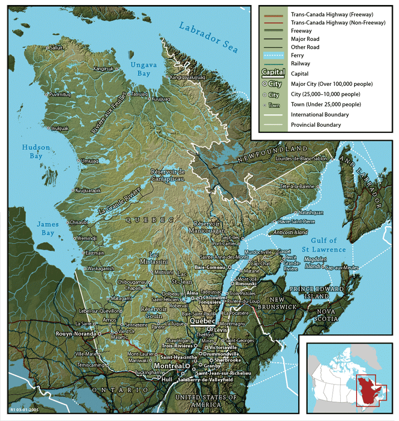
Monts Otish
Range
Country Canada
Province Quebec
Highest point Mont Yapeitso
 - elevation 1,135 m (3,724 ft)
 - coordinates 52°19′20.28″N 70°26′42.36″W / 52.3223°N 70.4451°W / 52.3223; -70.4451
The Otish Mountains are the tall hills between Lac Mistassini and Manicouagan Reservoir, in the geographic center of Quebec

The Monts Otish (Otish Mountains) are a range of tall hills in the geographic center of Quebec, Canada, north of Lac Mistassini and Manicouagan Reservoir. Within the tall hills is the Réserve faunique des Lacs-Albanel-Mistassini-et-Waconichi.


Wikimedia Foundation. 2010.

Игры ⚽ Нужно решить контрольную?

Look at other dictionaries:

  • Quebec — This article is about the Canadian province. For the province s capital city, see Quebec City. For other uses, see Quebec (disambiguation). Coordinates …   Wikipedia

  • Superior craton — in the west. The western margin extends from northern Minnesota through eastern Manitoba to northwestern Ontario.The formation of the Superior craton is best explained within the context of 2.72 2.68 Ga accretion of small continental plates and… …   Wikipedia

  • Rivière aux Outardes — Coordinates: 49°03′43″N 68°27′58″W / 49.06194°N 68.46611°W / 49.06194; 68.46611 …   Wikipedia

  • Nord-du-Québec —   Region   Nord du Québec (administrative region) Coordinates …   Wikipedia

  • Eastmain River — ▪ river, Canada French  Rivière East main,         river in Nord du Québec region, western Quebec province, Canada, rising in the Otish Mountains of central Quebec, flowing nearly due west, and discharging into James Bay. Its course of about 500… …   Universalium

  • La Grande River — ▪ river, Quebec, Canada formerly  Fort George River,         river in Nord du Québec region, north central Quebec province, Canada. Rising from Nichicun Lake in the Otish Mountains of central Quebec, it descends 1,737 feet (529 m) in its westward …   Universalium

  • Outardes River — ▪ river, Quebec, Canada French  Rivière Aux Outardes,         river in Côte Nord (“North Shore”) region, east central Quebec province, Canada, rising in the Otish Mountains and flowing southward for 300 miles (480 km) through Lake Plétipi to the… …   Universalium

  • Mountain peaks of North America — Main article: Geography of North America Mount McKinley (Denali) in Alaska is the highest mountain peak of North America. This article comprises three sortable tables of major mountain peaks of greater North America. This article defines grea …   Wikipedia

  • Table of the major 100 km summits of North America — Main article: Mountain peaks of North America The following sortable table lists the 234 mountain peaks of greater North America with at least 100 kilometers (62.14 miles) of topographic isolation and at least 500 meters… …   Wikipedia

  • Most isolated mountain peaks of Canada — Barbeau Peak on Ellesmere Island is the highest point of Nunavut. Main article: Mountain peaks of Canada See also: Highest mountain peaks of Canada and Most prominent mountain peaks of Canada The following sortable table lists t …   Wikipedia

Share the article and excerpts

Direct link
Do a right-click on the link above
and select “Copy Link”