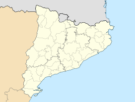
- Montmeneu
-
Montmeneu Elevation 494 m (1,621 ft) Location Segrià,  Catalonia
Range Isolated hill in the Catalan Central Depression Coordinates 41°23′19″N 0°24′05″E / 41.38861°N 0.40139°ECoordinates: 41°23′19″N 0°24′05″E / 41.38861°N 0.40139°E Geology Type Conglomerate Climbing First ascent Unknown Easiest route From La Granja d'Escarp, Seròs or Maials Montmeneu (Catalan pronunciation: [mumːəˈnew], locally: [momːeˈnew]) is a mountain of Catalonia, Spain. It is located in the La Granja d'Escarp and Seròs municipal limits, Segrià.
It is an isolated hill of the Catalan Central Depression,[1] visible from far away.
See also
- Mountains of Catalonia
References
- ^ "Mapa Topogràfic de Catalunya". Institut Cartogràfic de Catalunya. http://www.icc.cat/vissir2/. Retrieved May 22, 2010.
External links
- Map Segrià, ICC 1:50.000
- Wikiloc - Montmeneu hiking route
- Cim comarcals: Segrià. Montmeneu
Categories:- Catalonia geography stubs
- Mountains of Catalonia
- Segrià
Wikimedia Foundation. 2010.


