Moccasin Gap

Moccasin Gap
Moccasin Gap

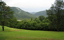
Moccasin Gap is a gap in Clinch Mountain near Gate City, Virginia, United States, the county seat of Scott County. Daniel Boone's Wilderness Road once traveled through the gap, on its way north from the Long Island of the Holston River, located to the south in Tennessee, towards the well-known Cumberland Gap at the boundary of Kentucky, Tennessee, and Virginia.

Moccasin Gap is the more dramatic of only two true, natural gaps in Clinch Mountain, but it is planned to undergo major mountain removal to accommodate a planned highway. The natural appearance of the gap will be altered significantly.[citation needed]


Wikimedia Foundation. 2010.

Игры ⚽ Поможем решить контрольную работу

Look at other dictionaries:

  • Silver Moccasin Trail — Infobox Hiking trail Name=Silver Moccasin Trail Photo=Silver Moccasin.jpg Caption=View along the Silver Moccasin Trail Length=53 mi; 85.3 km Location=California, United States Start/End Points=Chantry Flat above Arcadia, California Vincent Gap… …   Wikipedia

  • Clinch Mountain — Elevation 4,689 ft (1,429 m) ( Beartown Mountain summit) Location Location …   Wikipedia

  • Scott County, Virginia — Infobox U.S. County county = Scott County state = Virginia map size = 225 founded = November 24, 1814 seat = Gate City | area total sq mi =539 area water sq mi =2 area percentage = 0.38% census yr = 2000 pop = 23403 density km2 =17 web =… …   Wikipedia

  • National Register of Historic Places listings in Leon County, Florida — Location of Leon County in Florida This is a list of the National Register of Historic Places listings in Leon County, Florida. This is intended to be a complete list of the properties and districts on the National Register of Historic Places in… …   Wikipedia

  • Gate City, Virginia — Infobox Settlement official name = Gate City, Virginia settlement type = Town nickname = motto = imagesize = image caption = image mapsize = 250px map caption = Location of Gate City, Virginia mapsize1 = map caption1 = subdivision type = Country… …   Wikipedia

  • Miccosukee, Florida — Miccosukee is a historical small unincorporated community in northeastern Leon County, Florida, United States. It is located at the junction of County Road 59 (Veterans Memorial Drive) and County Road 151 (Moccasin Gap Road). Miccosukee was a… …   Wikipedia

  • Wilderness Road — The Wilderness Road was the principal route used by settlers to reach Kentucky for more than fifty years. In 1775, Daniel Boone blazed a trail for the Transylvania Company from Fort Chiswell in Virginia through the Cumberland Gap into central… …   Wikipedia

  • Virginia State Route 71 — Infobox road state=VA type= route=71 length mi=35.82 length ref=PDFlink| [http://www.virginiadot.org/info/resources/AADT 084 Scott 2005.pdf 2005 Virginia Department of Transportation Jurisdiction Report Daily Traffic Volume Estimates Scott… …   Wikipedia

  • Weber City, Virginia — Infobox Settlement official name = Weber City, Virginia settlement type = Town nickname = motto = imagesize = image caption = image mapsize = 250px map caption = Location of Weber City, Virginia mapsize1 = map caption1 = subdivision type =… …   Wikipedia

  • U.S. Route 23 in Virginia — Infobox road state=VA type=US route=23 length mi=61.16 length ref=PDFlink| [http://www.virginiadot.org/info/resources/AADT 084 Scott 2005.pdf 2005 Virginia Department of Transportation Jurisdiction Report Daily Traffic Volume Estimates Scott… …   Wikipedia

Share the article and excerpts

Direct link
Do a right-click on the link above
and select “Copy Link”