- Mittelberg (Thuringian Highland)
-
Mittelberg Thuringia, Germany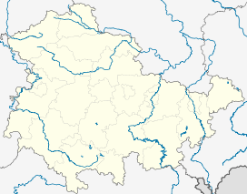
 Mittelberg
Elevation 803.6 m (2,636 ft) Location Range Thuringian Forest Coordinates 50°30′42″N 11°11′32″E / 50.51167°N 11.19222°ECoordinates: 50°30′42″N 11°11′32″E / 50.51167°N 11.19222°E 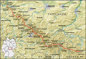 Map of the Rennsteig trail
The Mittelberg is a 803.6 m high (above sea level) mountain located in the Thuringian Highland, Thuringia (Germany).
It is located close to the municipalities of Piesau and Lichte and the Leibis-Lichte Dam in the Saalfeld-Rudolstadt district in the Thuringian Forest Nature Park.
The section of the Rennsteig walkway between Neuhaus am Rennweg, Ernstthal am Rennsteig, and Spechtsbrunn runs close to the mountain.
Neighbouring mountains Description Height
above sea level
Direction Particularity Apelsberg 785.3 m W Coniferous forest Rückersbiel 755.6 m W NW with the Sauhuegel (722 m, W) Hahnberg 685.3 m NW Pastureland Mutzenberg 770.0.6 m N NE Coniferous forest Rauhhügel 801.9 m N NE Observation tower, radio mast See also
- List of Mountains and Elevations of Thuringia
- This article incorporates information from the equivalent article on the German Wikipedia.
Categories:- Thuringia geography stubs
- Mountains of Thuringia
- Thuringian Forest
- Lichte


Wikimedia Foundation. 2010.